
Mapa topográfico Parma
Mapa interactivo
Haga clic en el mapa para ver la altitud.
Acerca de este mapa
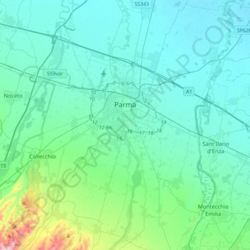
Nombre: Mapa topográfico Parma, altitud, relieve.
Lugar: Parma, Emilia-Romagna, Italy (44.66240 10.21481 44.90074 10.44364)
Altitud media: 85 m
Altitud mínima: 23 m
Altitud máxima: 486 m
During World War II, Parma was a strong centre of partisan resistance. The train station and marshalling yards were targets for high altitude bombing by the Allies in the spring of 1944. Much of the Palazzo della Pilotta, situated not far (half a mile) from the train station, was destroyed. Along with it the Teatro Farnese and part of the Biblioteca Palatina were destroyed by Allied bombs; some 21,000 volumes of the library's collection were lost. Several other monuments were also damaged: Palazzo del Giardino, Steccata and San Giovanni churches, Palazzo Ducale, Paganini theater and the monument to Verdi. However, Parma did not see widespread destruction during the war. Parma was liberated from the German occupation (1943–1945) on 26 April 1945 by the partisan resistance and the Brazilian Expeditionary Force.
Otros mapas topográficos
Haga clic en un mapa para ver su topografía, su altitud y su relieve.
Bedonia
Italy > Emilia-Romagna > Parma
Bedonia, Parma, Emilia-Romagna, 43041, Italy
Altitud media: 848 m
Polesine Zibello
Italy > Emilia-Romagna > Parma
Polesine Zibello, Parma, Emilia-Romagna, 43016, Italy
Altitud media: 35 m
Lodrignano
Italy > Emilia-Romagna > Parma > Neviano degli Arduini
Lodrignano, Neviano degli Arduini, Parma, Emilia-Romagna, 43024, Italy
Altitud media: 440 m
Valmozzola
Italy > Emilia-Romagna > Parma
Valmozzola, Parma, Emilia-Romagna, 43050, Italy
Altitud media: 675 m
Varsi
Italy > Emilia-Romagna > Parma > Varsi
Varsi, Parma, Emilia-Romagna, 43049, Italy
Altitud media: 633 m
Busseto
Italy > Emilia-Romagna > Parma
Busseto, Parma, Emilia-Romagna, 43011, Italy
Altitud media: 47 m