
Mapa topográfico Frisco
Mapa interactivo
Haga clic en el mapa para ver la altitud.
Acerca de este mapa
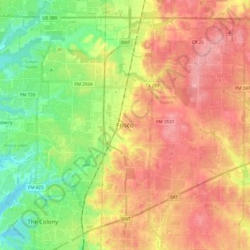
Nombre: Mapa topográfico Frisco, altitud, relieve.
Lugar: Frisco, Collin County, Texas, United States (33.08150 -96.92279 33.21958 -96.73257)
Altitud media: 201 m
Altitud mínima: 152 m
Altitud máxima: 247 m
In 1902, a line of the St. Louis–San Francisco Railway ("the Frisco") was being built through the area, and periodic watering stops were needed along the route for the steam locomotives. The current settlement of Lebanon was on Preston Ridge and was too high in elevation, so the watering stop was placed about 4 miles (6 km) to the west on lower ground. A community grew around this train stop, and some Lebanon residents moved their houses to the new community on logs. The new town was originally named Emerson, but the U.S. Postal Service rejected the name as too similar to another community, Emberson, in Lamar County.
Otros mapas topográficos
Haga clic en un mapa para ver su topografía, su altitud y su relieve.
Allen
United States > Texas > Collin County
Allen, Collin County, Texas, United States
Altitud media: 200 m
Plano
United States > Texas > Collin County
Plano, Collin County, Texas, United States
Altitud media: 196 m
Desert
United States > Texas > Collin County > Desert
Desert, Collin County, Texas, United States
Altitud media: 206 m