
Mapa topográfico Schwendt
Mapa interactivo
Haga clic en el mapa para ver la altitud.
Acerca de este mapa
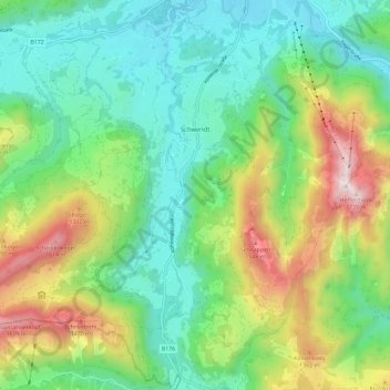
Nombre: Mapa topográfico Schwendt, altitud, relieve.
Lugar: Schwendt, Bezirk Kitzbühel, 6385, Austria (47.58594 12.32041 47.65149 12.43646)
Altitud media: 948 m
Altitud mínima: 582 m
Altitud máxima: 1.733 m
Otros mapas topográficos
Haga clic en un mapa para ver su topografía, su altitud y su relieve.
Scheffau
Austria > Bezirk Kitzbühel > Sankt Johann in Tirol
Scheffau, Sankt Johann in Tirol, Bezirk Kitzbühel, Austria
Altitud media: 939 m
Mittagskogel
Austria > Bezirk Kitzbühel > Jochberg
Mittagskogel, Jochberg, Bezirk Kitzbühel, Austria
Altitud media: 1.838 m
Gemeinde Kössen
Gemeinde Kössen, Bezirk Kitzbühel, Tyrol, 6345, Austria
Altitud media: 979 m