
Mapa topográfico Cher
Mapa interactivo
Haga clic en el mapa para ver la altitud.
Acerca de este mapa
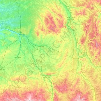
Nombre: Mapa topográfico Cher, altitud, relieve.
Lugar: Cher, Centre-Val de Loire, Metropolitan France, France (46.42046 1.77390 47.62910 3.07921)
Altitud media: 207 m
Altitud mínima: 81 m
Altitud máxima: 495 m
Otros mapas topográficos
Haga clic en un mapa para ver su topografía, su altitud y su relieve.
Dreux
France > Centre-Val de Loire > Eure-et-Loir
Dreux, Eure-et-Loir, Centre-Val de Loire, Metropolitan France, 28100, France
Altitud media: 113 m
L'Esperance
France > Centre-Val de Loire > Indre-et-Loire > Nouzilly
L'Esperance, Nouzilly, Loches, Indre-et-Loire, Centre-Val de Loire, Metropolitan France, 37380, France
Altitud media: 115 m
Loches
France > Centre-Val de Loire > Indre-et-Loire
Loches, Indre-et-Loire, Centre-Val de Loire, Metropolitan France, 37600, France
Altitud media: 106 m
Tours
France > Centre-Val de Loire > Indre-et-Loire
Tours, Arrondissement de Tours, Indre-et-Loire, Centre-Val de Loire, Metropolitan France, France
Altitud media: 73 m
Loiret
Loiret, Centre-Val de Loire, Metropolitan France, France
Altitud media: 135 m
Mardié
France > Centre-Val de Loire > Loiret
Mardié, Orléans, Loiret, Centre-Val de Loire, Metropolitan France, 45430, France
Altitud media: 110 m