
Mapa topográfico Marlpool
Haga clic en el mapa para ver la altitud.
Acerca de este mapa
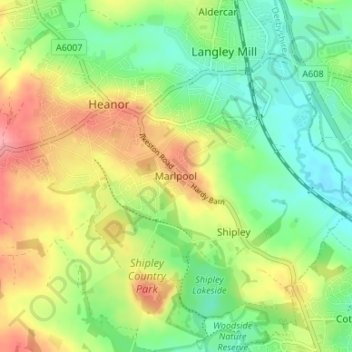
Nombre: Mapa topográfico Marlpool, altitud, relieve.
Altitud media: 90 m
Altitud mínima: 51 m
Altitud máxima: 143 m
Otros mapas topográficos
Haga clic en un mapa para ver su topografía, su altitud y su relieve.
Dethick, Lea and Holloway CP
United Kingdom > England > Derbyshire > Amber Valley > Dethick
Altitud media: 204 m
Crich CP
United Kingdom > England > Derbyshire > Amber Valley
The memorial tower ('Crich Stand') was completed in 1923 as a memorial to the 11,409 soldiers from the Sherwood Foresters Regiment who died in World War I, a dedication that was later extended to include World War II. It was built on an limestone outcrop above the village, at an altitude of 1,000 feet (300 m)…
Altitud media: 159 m
Shipley Country Park
United Kingdom > England > Derbyshire > Amber Valley > Marlpool
Altitud media: 93 m
Nottingham Canal
United Kingdom > England > Derbyshire > Amber Valley > Langley Mill
Altitud media: 77 m
Alfreton Park
United Kingdom > England > Derbyshire > Amber Valley > Alfreton CP > Oakerthorpe
Altitud media: 116 m