
Mapa topográfico Freising
Mapa interactivo
Haga clic en el mapa para ver la altitud.
Acerca de este mapa
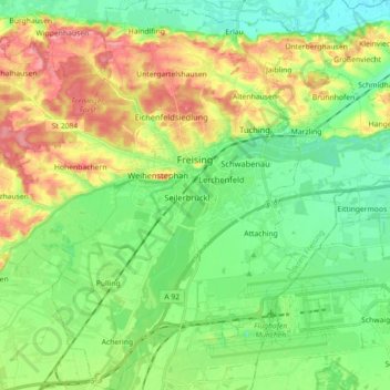
Nombre: Mapa topográfico Freising, altitud, relieve.
Lugar: Freising, Landkreis Freising, Bavaria, Germany (48.33061 11.64045 48.44903 11.79251)
Altitud media: 457 m
Altitud mínima: 419 m
Altitud máxima: 522 m
In 1802/1803 Bavaria fell under the influence of Napoleonic France in which church controlled lands were secularized. In Freising, the more than thousand-year-old bishopric was abolished. The Roman Catholic Church lost most of its properties and authority over the city. Though the seat of the diocese was moved to Munich in 1821, including the elevation to an archdiocese, Freising has remained the seat of diocesan administration until today.
Otros mapas topográficos
Haga clic en un mapa para ver su topografía, su altitud y su relieve.
Neufahrn bei Freising
Germany > Bavaria > Landkreis Freising
Neufahrn bei Freising, Landkreis Freising, Bavaria, Germany
Altitud media: 464 m
85413
Germany > Bavaria > Landkreis Freising > Margarethenried > Sixt in der Point
85413, Sixt in der Point, Margarethenried, Hörgertshausen, Mauern (VGem), Landkreis Freising, Bavaria, Germany
Altitud media: 484 m
Dietersheim
Germany > Bavaria > Landkreis Freising
Dietersheim, Eching, Landkreis Freising, Bavaria, 85386, Germany
Altitud media: 471 m
Günzenhausen
Germany > Bavaria > Landkreis Freising
Günzenhausen, Eching, Landkreis Freising, Bavaria, 85376, Germany
Altitud media: 477 m
Mariabrunn
Germany > Bavaria > Landkreis Freising > Birkeneck
Mariabrunn, Birkeneck, Hallbergmoos, Landkreis Freising, Bavaria, 85399, Germany
Altitud media: 453 m
Spörerau
Germany > Bavaria > Landkreis Freising > Wang
Spörerau, Wang, Mauern (VGem), Landkreis Freising, Bavaria, 84079, Germany
Altitud media: 410 m
Moosburg
Germany > Bavaria > Landkreis Freising
Moosburg, Landkreis Freising, Bavaria, 85368, Germany
Altitud media: 428 m