
Mapa topográfico Monongahela National Forest
Mapa interactivo
Haga clic en el mapa para ver la altitud.
Acerca de este mapa
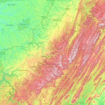
Nombre: Mapa topográfico Monongahela National Forest, altitud, relieve.
Altitud media: 655 m
Altitud mínima: 191 m
Altitud máxima: 1.474 m
In 1943 and 1944, as part of the West Virginia Maneuver Area, the U.S. Army used parts of the Monongahela National Forest as a practice artillery and mortar range and maneuver area before troops were sent to Europe to fight in World War II. Artillery and mortar shells shot into the area for practice are still occasionally found there today. Seneca Rocks and other area cliffs were also used for assault climbing instruction. This was the Army's only low-altitude climbing school.
Otros mapas topográficos
Haga clic en un mapa para ver su topografía, su altitud y su relieve.
Denmar
United States > West Virginia > Pocahontas County
Denmar, Pocahontas County, West Virginia, 24946, United States
Altitud media: 690 m
Green Bank Telescope
United States > West Virginia > Pocahontas County
Green Bank Telescope, Slavin Hollow Road, Pocahontas County, West Virginia, 24944, United States
Altitud media: 822 m
Marlinton
United States > West Virginia > Pocahontas County > Marlinton
Marlinton, Pocahontas County, West Virginia, 24924, United States
Altitud media: 791 m
Hillsboro
United States > West Virginia > Pocahontas County > Hillsboro
Hillsboro, Pocahontas County, West Virginia, United States
Altitud media: 706 m
Walnut
United States > West Virginia > Pocahontas County > Walnut
Walnut, Pocahontas County, West Virginia, 26291, United States
Altitud media: 1.041 m
Frank
United States > West Virginia > Pocahontas County
Frank, Pocahontas County, West Virginia, 26264, United States
Altitud media: 926 m
Cass
United States > West Virginia > Pocahontas County > Cass
Cass, Pocahontas County, West Virginia, United States
Altitud media: 839 m