
Haz una donación
Equípate para tu próxima aventura:
Como asociado de Amazon, este sitio gana comisiones por las compras que califican, sin ningún costo adicional para usted.
Mapa topográfico Englewood
Haga clic en el mapa para ver la altitud.
Haz una donación
Equípate para tu próxima aventura:
Como asociado de Amazon, este sitio gana comisiones por las compras que califican, sin ningún costo adicional para usted.
Englewood
Englewood features a diverse topography characterized by flat coastal plains and gently rolling terrain. The area is predominantly low-lying, with elevations rarely exceeding 20 feet above sea level, making it susceptible to tidal influences from the Gulf of Mexico. The landscape is interspersed with wetlands, estuaries, and salt marshes, particularly around Lemon Bay, which provide rich habitats for wildlife. Along the coastline, sandy beaches stretch for miles, offering a scenic backdrop against the turquoise waters. Inland, the terrain transitions into residential neighborhoods and parks, with sporadic pockets of vegetation, including pine and palm trees, contributing to the region's natural beauty.
Haz una donación
Equípate para tu próxima aventura:
Como asociado de Amazon, este sitio gana comisiones por las compras que califican, sin ningún costo adicional para usted.
Acerca de este mapa
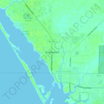
Nombre: Mapa topográfico Englewood, altitud, relieve.
Lugar: Englewood, Sarasota County, Florida, FL 34223, USA (26.92201 -82.39260 27.00201 -82.31260)
Altitud media: 3 m
Altitud mínima: -1 m
Altitud máxima: 11 m
Haz una donación
Equípate para tu próxima aventura:
Como asociado de Amazon, este sitio gana comisiones por las compras que califican, sin ningún costo adicional para usted.