
Mapa topográfico Pylos
Mapa interactivo
Haga clic en el mapa para ver la altitud.
Acerca de este mapa
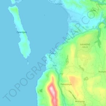
Nombre: Mapa topográfico Pylos, altitud, relieve.
Altitud media: 79 m
Altitud mínima: -6 m
Altitud máxima: 475 m
The erection of this fort led to one of the most memorable events in the Peloponnesian War. Thucydides has given a minute account of the topography of the district, which, though clear and consistent with itself, does not coincide, in all points, with the existing locality, Thucydides describes the harbour, of which the promontory Coryphasium (Koryphasion) formed the northern termination, as fronted and protected by the island Sphacteria, which stretched along the coast, leaving only two narrow entrances to the harbour,--the one at the northern end, opposite to Coryphasium, being only wide enough to admit two triremes abreast, and the other at the southern end wide enough for eight or nine triremes. The island was about 15 stadia in width, covered with wood, uninhabited and untrodden. Pausanias also says that the island Sphacteria lies before the harbour of Pylos like Rheneia before the anchorage of Delos. A little later the Athenians captured a number of Spartan troops besieged on the adjacent island of Sphacteria (see Battle of Sphacteria). Spartan anxiety over the return of the prisoners, who were taken to Athens as hostages, contributed to their acceptance of the Peace of Nicias in 421 BC.
Otros mapas topográficos
Haga clic en un mapa para ver su topografía, su altitud y su relieve.
Stoupa
Greece > Peloponnese, Western Greece and the Ionian > Messenia Regional Unit > Municipal Unit of Lefktro
Stoupa, Municipal Unit of Lefktro, Municipality of West Mani, Messenia Regional Unit, Peloponnese Region, Peloponnese, Western Greece and the Ionian, 240 24, Greece
Altitud media: 63 m
Voreio
Greece > Peloponnese, Western Greece and the Ionian > Messenia Regional Unit > Municipal Unit of Avia
Voreio, Municipal Unit of Avia, Municipality of West Mani, Messenia Regional Unit, Peloponnese Region, Peloponnese, Western Greece and the Ionian, 240 16, Greece
Altitud media: 668 m
Palace of Nestor
Greece > Peloponnese, Western Greece and the Ionian > Messenia Regional Unit > Chora > Pisaski
Palace of Nestor, Old National Highway 9, Pisaski, Chora, Municipality of Pylos and Nestor, Messenia Regional Unit, Peloponnese Region, Peloponnese, Western Greece and the Ionian, 246 00, Greece
Altitud media: 146 m
Diavolitsi
Greece > Peloponnese, Western Greece and the Ionian > Messenia Regional Unit
Diavolitsi, Municipality of Oichalia, Messenia Regional Unit, Peloponnese Region, Peloponnese, Western Greece and the Ionian, 240 08, Greece
Altitud media: 157 m
Municipality of Pylos and Nestor
Greece > Peloponnese, Western Greece and the Ionian > Messenia Regional Unit
Municipality of Pylos and Nestor, Messenia Regional Unit, Peloponnese Region, Peloponnese, Western Greece and the Ionian, Greece
Altitud media: 101 m
Καλαμάκι
Greece > Peloponnese, Western Greece and the Ionian > Messenia Regional Unit
Καλαμάκι, Municipality of Pylos and Nestor, Messenia Regional Unit, Peloponnese Region, Peloponnese, Western Greece and the Ionian, Greece
Altitud media: 344 m
Exochori
Greece > Peloponnese, Western Greece and the Ionian > Messenia Regional Unit > Municipal Unit of Lefktro
Exochori, Municipal Unit of Lefktro, Municipality of West Mani, Messenia Regional Unit, Peloponnese Region, Peloponnese, Western Greece and the Ionian, 240 22, Greece
Altitud media: 501 m
Κυπαρισσία
Greece > Peloponnese, Western Greece and the Ionian > Messenia Regional Unit > Kyparissia Municipal Unit > Κυπαρισσία
Κυπαρισσία, Kyparissia Municipal Unit, Municipality of Trifylia, Messenia Regional Unit, Peloponnese Region, Peloponnese, Western Greece and the Ionian, 24500, Greece
Altitud media: 152 m
Municipality of Kalamata
Greece > Peloponnese, Western Greece and the Ionian > Messenia Regional Unit
Municipality of Kalamata, Messenia Regional Unit, Peloponnese Region, Peloponnese, Western Greece and the Ionian, Greece
Altitud media: 490 m