
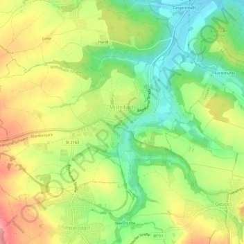
Mapa topográfico Mistelbach
Mapa interactivo
Haga clic en el mapa para ver la altitud.
Acerca de este mapa
Nombre: Mapa topográfico Mistelbach, altitud, relieve.
Altitud media: 409 m
Altitud mínima: 352 m
Altitud máxima: 475 m
Otros mapas topográficos
Haga clic en un mapa para ver su topografía, su altitud y su relieve.
Hollfeld
Deutschland > Bayern > Landkreis Bayreuth
Hollfeld, Hollfeld (VGem), Landkreis Bayreuth, Bayern, 96142, Deutschland
Altitud media: 449 m
Rosenhof
Deutschland > Bayern > Landkreis Bayreuth > Pegnitz
Rosenhof, Pegnitz, Landkreis Bayreuth, Bayern, 91257, Deutschland
Altitud media: 475 m
Heßlach
Deutschland > Bayern > Landkreis Bayreuth > Weidenberg
Heßlach, Weidenberg, Weidenberg (VGem), Landkreis Bayreuth, Bayern, 95466, Deutschland
Altitud media: 538 m
Fröbershammer
Deutschland > Bayern > Landkreis Bayreuth
Fröbershammer, Bischofsgrün, Landkreis Bayreuth, Bayern, 95493, Deutschland
Altitud media: 757 m