
Haz una donación
Equípate para tu próxima aventura:
Como asociado de Amazon, este sitio gana comisiones por las compras que califican, sin ningún costo adicional para usted.
Mapa topográfico Mount Columbia
Haga clic en el mapa para ver la altitud.
Haz una donación
Equípate para tu próxima aventura:
Como asociado de Amazon, este sitio gana comisiones por las compras que califican, sin ningún costo adicional para usted.
Mount Columbia
Mount Columbia is a mountain located in the Winston Churchill Range of the Rocky Mountains. It is the highest point in Alberta, Canada, and is second only to Mount Robson for height and topographical prominence in the Canadian Rockies. It is located on the border between Alberta and British Columbia on the northern edge of the Columbia Icefield. Its highest point, however, lies within Jasper National Park in Alberta.
Haz una donación
Equípate para tu próxima aventura:
Como asociado de Amazon, este sitio gana comisiones por las compras que califican, sin ningún costo adicional para usted.
Acerca de este mapa
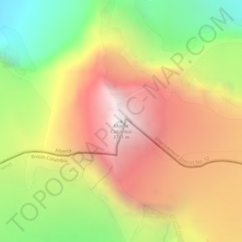
Nombre: Mapa topográfico Mount Columbia, altitud, relieve.
Altitud media: 2.841 m
Altitud mínima: 1.858 m
Altitud máxima: 3.752 m
Haz una donación
Equípate para tu próxima aventura:
Como asociado de Amazon, este sitio gana comisiones por las compras que califican, sin ningún costo adicional para usted.
Otros mapas topográficos
Haga clic en un mapa para ver su topografía, su altitud y su relieve.
Maligne Lake
Canada > Alberta > Improvement District No. 12
Wildlife is surprisingly abundant along this high altitude oligotrophic lake. Grizzly bear, black bear, mule deer, caribou, wolves, moose, and mountain sheep are some of the larger mammals that frequent the lake area during the summer season. Bald eagles, golden eagles and osprey also frequent the area and…
Altitud media: 2.125 m
Haz una donación
Equípate para tu próxima aventura:
Como asociado de Amazon, este sitio gana comisiones por las compras que califican, sin ningún costo adicional para usted.
Lawrence Glacier
Canada > Alberta > Improvement District No. 12 > Area A (Kicking Horse/Kinbasket Lake)
Altitud media: 2.619 m
Maligne Lake
Canada > Alberta > Improvement District No. 12
Wildlife is surprisingly abundant along this high altitude oligotrophic lake. Grizzly bear, black bear, mule deer, caribou, wolves, moose, and mountain sheep are some of the larger mammals that frequent the lake area during the summer season. Bald eagles, golden eagles and osprey also frequent the area and…
Altitud media: 2.125 m
Haz una donación
Equípate para tu próxima aventura:
Como asociado de Amazon, este sitio gana comisiones por las compras que califican, sin ningún costo adicional para usted.