
Mapa topográfico Cartersville
Mapa interactivo
Haga clic en el mapa para ver la altitud.
Acerca de este mapa
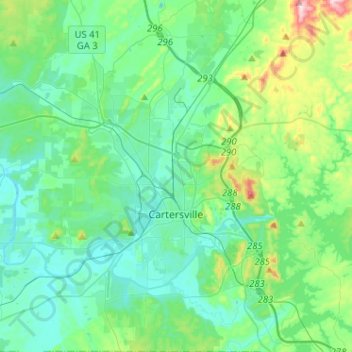
Nombre: Mapa topográfico Cartersville, altitud, relieve.
Lugar: Cartersville, Bartow County, Georgia, 30120, United States (34.08243 -84.86588 34.29379 -84.73650)
Altitud media: 260 m
Altitud mínima: 195 m
Altitud máxima: 531 m
Otros mapas topográficos
Haga clic en un mapa para ver su topografía, su altitud y su relieve.
Emerson
United States > Georgia > Bartow County
Emerson, Bartow County, Georgia, 30137, United States
Altitud media: 254 m
Rydal
United States > Georgia > Bartow County > Rydal
Rydal, Bartow County, Georgia, 30139:30171:30184, United States
Altitud media: 273 m
White
United States > Georgia > Bartow County > White
White, Bartow County, Georgia, United States
Altitud media: 271 m