
Haz una donación
Equípate para tu próxima aventura:
Como asociado de Amazon, este sitio gana comisiones por las compras que califican, sin ningún costo adicional para usted.
Mapa topográfico Musina
Haga clic en el mapa para ver la altitud.
Haz una donación
Equípate para tu próxima aventura:
Como asociado de Amazon, este sitio gana comisiones por las compras que califican, sin ningún costo adicional para usted.
Acerca de este mapa
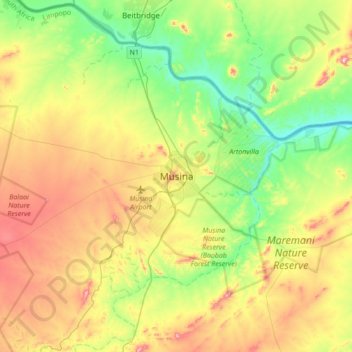
Nombre: Mapa topográfico Musina, altitud, relieve.
Altitud media: 535 m
Altitud mínima: 399 m
Altitud máxima: 747 m
Haz una donación
Equípate para tu próxima aventura:
Como asociado de Amazon, este sitio gana comisiones por las compras que califican, sin ningún costo adicional para usted.
Otros mapas topográficos
Haga clic en un mapa para ver su topografía, su altitud y su relieve.
Nzhelele
South Africa > Limpopo > Vhembe District Municipality > Makhado Local Municipality
Altitud media: 675 m
Thulamela Local Municipality
South Africa > Limpopo > Vhembe District Municipality
Altitud media: 492 m
Haz una donación
Equípate para tu próxima aventura:
Como asociado de Amazon, este sitio gana comisiones por las compras que califican, sin ningún costo adicional para usted.
Nandoni Dam
South Africa > Limpopo > Vhembe District Municipality > Thulamela Local Municipality
Altitud media: 503 m
Mutshindudi
South Africa > Limpopo > Vhembe District Municipality > Thulamela Local Municipality
The Mutshindudi River is a river in the Limpopo Province of South Africa, it originates in the Soutpansberg mountains. It is a right-hand tributary of the Levuvhu River. Its elevation is 534 metres above the sea level. It is about 50 km long and drops steeply from a high rain fall region at 1200m to a lowland…
Altitud media: 702 m
Entabeni Forest Reserve
South Africa > Limpopo > Vhembe District Municipality > Makhado Local Municipality
Altitud media: 1.145 m
Haz una donación
Equípate para tu próxima aventura:
Como asociado de Amazon, este sitio gana comisiones por las compras que califican, sin ningún costo adicional para usted.
Venetia Limpopo Nature Reserve
South Africa > Limpopo > Vhembe District Municipality
Altitud media: 635 m
Mutale
South Africa > Limpopo > Vhembe District Municipality > Mutale Local Municipality
Altitud media: 755 m
Mutale
South Africa > Limpopo > Vhembe District Municipality > Thulamela Local Municipality
Altitud media: 1.016 m
Haz una donación
Equípate para tu próxima aventura:
Como asociado de Amazon, este sitio gana comisiones por las compras que califican, sin ningún costo adicional para usted.
Thulamela Local Municipality
South Africa > Limpopo > Vhembe District Municipality
Altitud media: 492 m
Mapungubwe Cultural Landscape
South Africa > Limpopo > Vhembe District Municipality
Altitud media: 651 m
Nandoni Dam
South Africa > Limpopo > Vhembe District Municipality > Thulamela Local Municipality
Altitud media: 503 m
Haz una donación
Equípate para tu próxima aventura:
Como asociado de Amazon, este sitio gana comisiones por las compras que califican, sin ningún costo adicional para usted.