
Mapa topográfico Vaux
Mapa interactivo
Haga clic en el mapa para ver la altitud.
Acerca de este mapa
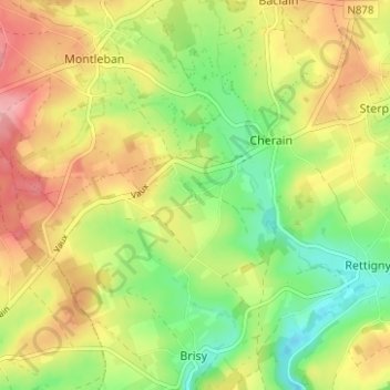
Nombre: Mapa topográfico Vaux, altitud, relieve.
Altitud media: 436 m
Altitud mínima: 377 m
Altitud máxima: 501 m
Otros mapas topográficos
Haga clic en un mapa para ver su topografía, su altitud y su relieve.
Wathermal
Belgique > Luxembourg > Bastogne > Gouvy
Wathermal, Beho, Gouvy, Bastogne, Luxembourg, Wallonie, 6672, Belgique
Altitud media: 489 m
Beho
Belgique > Luxembourg > Bastogne > Gouvy
Beho, Gouvy, Bastogne, Luxembourg, Wallonie, 6672, Belgique
Altitud media: 491 m
Limerlé
Belgique > Luxembourg > Bastogne > Gouvy
Limerlé, Gouvy, Bastogne, Luxembourg, Wallonie, Belgique
Altitud media: 471 m
Gouvy
Belgique > Luxembourg > Bastogne > Gouvy
Gouvy, Bastogne, Luxembourg, Wallonie, Belgique
Altitud media: 469 m