
Mapa topográfico Smith Mills
Mapa interactivo
Haga clic en el mapa para ver la altitud.
Acerca de este mapa
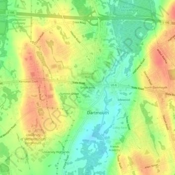
Nombre: Mapa topográfico Smith Mills, altitud, relieve.
Altitud media: 29 m
Altitud mínima: 2 m
Altitud máxima: 55 m
Otros mapas topográficos
Haga clic en un mapa para ver su topografía, su altitud y su relieve.
South Dartmouth
United States > Massachusetts > Bristol County > Dartmouth > South Dartmouth
South Dartmouth, Dartmouth, Bristol County, Massachusetts, 02748, United States
Altitud media: 3 m