
Mapa topográfico Timms Hill
Mapa interactivo
Haga clic en el mapa para ver la altitud.
Acerca de este mapa
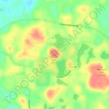
Nombre: Mapa topográfico Timms Hill, altitud, relieve.
Altitud media: 553 m
Altitud mínima: 518 m
Altitud máxima: 590 m
Timms Hill or Timm's Hill is the highest natural point in the U.S. state of Wisconsin and is located in north-central Wisconsin in Timms Hill County Park in the Town of Hill in Price County. After being surveyed by Quentin Stevens of Ogema Telephone Co in 1962, Timms Hill was discovered to have an elevation of 1,951.5 ft (595 m). It is less than 1 mile (1.6 km) south of Highway 86, about midway between Ogema and Spirit and about 23 miles (37 km) west of Tomahawk.
Otros mapas topográficos
Haga clic en un mapa para ver su topografía, su altitud y su relieve.
Kennan
United States > Wisconsin > Price County
Kennan, Price County, Wisconsin, United States
Altitud media: 457 m
Dover
United States > Wisconsin > Price County
Dover, Town of Emery, Price County, Wisconsin, United States
Altitud media: 504 m
Worcester
United States > Wisconsin > Price County
Worcester, Town of Hackett, Price County, Wisconsin, United States
Altitud media: 486 m
Ogema
United States > Wisconsin > Price County
Ogema, Town of Ogema, Price County, Wisconsin, United States
Altitud media: 477 m
Smith Lake County Park
United States > Wisconsin > Price County > Park Falls
Smith Lake County Park, Park Falls, Town of Eisenstein, Price County, Wisconsin, 54896, United States
Altitud media: 451 m
Phillips
United States > Wisconsin > Price County
Phillips, Price County, Wisconsin, 54555, United States
Altitud media: 446 m
Catawba
United States > Wisconsin > Price County
Catawba, Price County, Wisconsin, United States
Altitud media: 455 m
Kennedy
United States > Wisconsin > Price County > Kennedy
Kennedy, Town of Lake, Price County, Wisconsin, United States
Altitud media: 448 m
Prentice
United States > Wisconsin > Price County
Prentice, Price County, Wisconsin, 54556, United States
Altitud media: 473 m