
Mapa topográfico Cabra Island
Mapa interactivo
Haga clic en el mapa para ver la altitud.
Acerca de este mapa
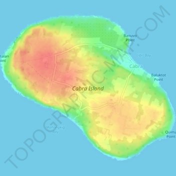
Nombre: Mapa topográfico Cabra Island, altitud, relieve.
Altitud media: 17 m
Altitud mínima: -1 m
Altitud máxima: 56 m
With a length of about 4.5 km (2.8 miles) and about 2.9 km (1.8 miles) at its widest, the island has a flat terrain with the highest elevation at 60.96 metres (around 200 feet). A particular rock islet near one beach is considered by locals as a symbol of the island given its shape as a cabra (Spanish for “goat”). The Cabra Island Lighthouse complex is located on Cabra Island.