
Mapa topográfico Province of Morropón
Mapa interactivo
Haga clic en el mapa para ver la altitud.
Acerca de este mapa
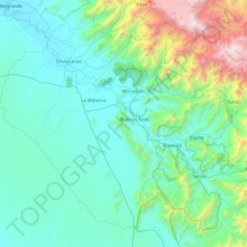
Nombre: Mapa topográfico Province of Morropón, altitud, relieve.
Lugar: Province of Morropón, Piura, Peru (-5.63003 -80.36502 -4.92783 -79.64221)
Altitud media: 603 m
Altitud mínima: 60 m
Altitud máxima: 3.662 m
This province is located in the center of the Piura Region, being a land of contrast and climatic fusion. It is dotted by tropical forests of the dry-equatorial style in its flat areas were the carob tree predominates. In high areas of an elevation 1,500 to 2,000 metres (4,900–6,600 ft) the landscape changes to smooth high jungle and a lack of varied hilly valleys.
Otros mapas topográficos
Haga clic en un mapa para ver su topografía, su altitud y su relieve.
Lucarqui
Peru > Piura > Distrito de Ayabaca
Lucarqui, Distrito de Ayabaca, Province of Ayabaca, Piura, Peru
Altitud media: 1.862 m
Parque Miguel Cortés
Parque Miguel Cortés, Urbanización 4 de Enero, Piura, Province of Piura, Piura, Peru
Altitud media: 32 m
Cerro Vicús
Peru > Piura > Chulucanas
Cerro Vicús, Chulucanas, Morropón, Piura, Peru
Altitud media: 171 m
Aypate
Peru > Piura > Distrito de Ayabaca
Aypate, PE-3N, Distrito de Ayabaca, Ayabaca, Piura, Peru
Altitud media: 2.568 m