Geolocalizar

Mapa topográfico Eskdalemuir

Mapa interactivo

Haga clic en el mapa para ver la altitud.

Acerca de este mapa

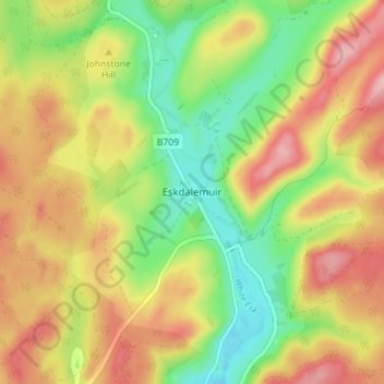
Nombre: Mapa topográfico Eskdalemuir, altitud, relieve.

Lugar: Eskdalemuir, Dumfries and Galloway, Scotland, DG13 0QF, United Kingdom (55.25407 -3.20191 55.29407 -3.16191)

Altitud media: 246 m

Altitud mínima: 175 m

Altitud máxima: 319 m

In spite of it being located inland, the dull and wet nature of the climate due to the elevation leads to chilly summers that are colder than more northerly locations such as Glasgow and Edinburgh. The inland nature of the climate is more manifest during winter months with frosts being common, and the average lows between December and February are below the freezing point.

Wikipedia (CC-BY-SA 3.0)

Otros mapas topográficos

Haga clic en un mapa para ver su topografía, su altitud y su relieve.

Fingland

United Kingdom > Scotland > Dumfries and Galloway

Fingland, Dumfries and Galloway, Scotland, DG11 2LD, United Kingdom

Altitud media: 206 m

Durisdeer

United Kingdom > Scotland > Dumfries and Galloway

Durisdeer, Dumfries and Galloway, Scotland, DG3 5BJ, United Kingdom

Altitud media: 270 m

Moniaive

United Kingdom > Scotland > Dumfries and Galloway

Moniaive, Dumfries and Galloway, Scotland, DG3 4HN, United Kingdom

Altitud media: 179 m

Doons

United Kingdom > Scotland > Dumfries and Galloway

Doons, Dumfries and Galloway, Scotland, DG3 4NG, United Kingdom

Altitud media: 202 m