
Mapa topográfico Xiangning County
Mapa interactivo
Haga clic en el mapa para ver la altitud.
Acerca de este mapa
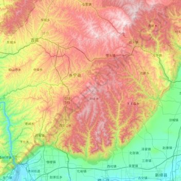
Nombre: Mapa topográfico Xiangning County, altitud, relieve.
Lugar: Xiangning County, Linfen, Shanxi, China (35.68929 110.50663 36.14994 111.28696)
Altitud media: 977 m
Altitud mínima: 376 m
Altitud máxima: 1.804 m
The county is located in the Lüliang Mountains of the Loess Plateau, and has a largely hilly terrain with an average elevation of about 900 metres (3,000 ft). The county's highest point is Gaotian Mountain (Chinese: 高天山), which reaches 1,820.5 metres (5,973 ft) in altitude; the county's lowest point is along the banks of the Yellow River, at 385.1 metres (1,263 ft) in altitude.
Otros mapas topográficos
Haga clic en un mapa para ver su topografía, su altitud y su relieve.
Qingxu County
China > Shanxi > Qingxu County
Qingxu County, Taiyuan City, Shanxi, China
Altitud media: 913 m
Gujiao City
China > Shanxi > Gujiao City
Gujiao City, Taiyuan City, Shanxi, China
Altitud media: 1.379 m
Taiyuan
China > Shanxi > Taiyuan > Sanqiao Subdistrict
Taiyuan, Sanqiao Subdistrict, Xinghualing District, Taiyuan City, Shanxi, 030002, China
Altitud media: 982 m