
Mapa topográfico Town of Hammond
Mapa interactivo
Haga clic en el mapa para ver la altitud.
Acerca de este mapa
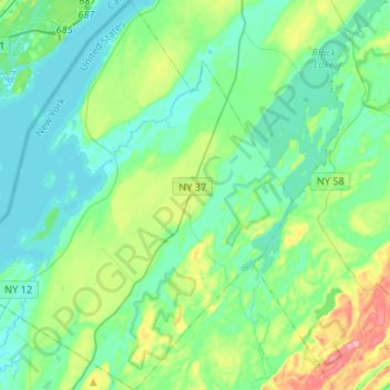
Nombre: Mapa topográfico Town of Hammond, altitud, relieve.
Altitud media: 99 m
Altitud mínima: 72 m
Altitud máxima: 190 m
The Village of Hammond is located at 44°26′56″N 75°41′39″W / 44.44889°N 75.69417°W / 44.44889; -75.69417Coordinates: 44°26′56″N 75°41′39″W / 44.44889°N 75.69417°W / 44.44889; -75.69417. The elevation is 358 feet (109 m).
Otros mapas topográficos
Haga clic en un mapa para ver su topografía, su altitud y su relieve.
Cedar Island State Park
United States > New York > Saint Lawrence County > Town of Hammond
Cedar Island State Park, Town of Hammond, Saint Lawrence County, New York, United States
Altitud media: 74 m