
Mapa topográfico Broken Bow
Mapa interactivo
Haga clic en el mapa para ver la altitud.
Acerca de este mapa
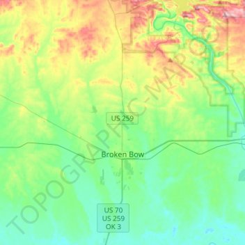
Nombre: Mapa topográfico Broken Bow, altitud, relieve.
Lugar: Broken Bow, McCurtain County, Oklahoma, United States (33.95544 -94.77445 34.15653 -94.70551)
Altitud media: 155 m
Altitud mínima: 95 m
Altitud máxima: 304 m
The city sits at the foothills of the Kiamichi Mountains, a subrange of the Ouachita Mountains. the Kiamichi Mountains sit within Le Flore, Pushmataha, and McCurtain counties near the towns of Poteau and Albion. The Kiamichi peaks line up south of the Kiamichi River and reach 2,500 feet (760 m) in elevation. The range is the namesake of Kiamichi Country, the official tourism designation for southeastern Oklahoma.
Otros mapas topográficos
Haga clic en un mapa para ver su topografía, su altitud y su relieve.
Broken Bow Lake
United States > Oklahoma > McCurtain County
Broken Bow Lake, McCurtain County, Oklahoma, United States
Altitud media: 158 m
Candy Mountain
United States > Oklahoma > McCurtain County
Candy Mountain, McCurtain County, Oklahoma, United States
Altitud media: 251 m
Sherwood
United States > Oklahoma > McCurtain County > Sherwood
Sherwood, McCurtain County, Oklahoma, United States
Altitud media: 307 m