
Mapa topográfico Gardner
Mapa interactivo
Haga clic en el mapa para ver la altitud.
Gardner
According to the United States Census Bureau, Gardner has a total area of 23.0 square miles (60 km2), of which 22.2 square miles (57 km2) is land and 0.8 square miles (2.1 km2), or 3.52%, is water. The city is situated on Crystal Lake. Its highest point is the summit of Reservoir Hill, close to the city center, with an elevation of over 1,280 feet (390 m) above sea level.
Acerca de este mapa
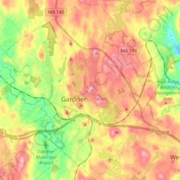
Nombre: Mapa topográfico Gardner, altitud, relieve.
Altitud media: 326 m
Altitud mínima: 259 m
Altitud máxima: 391 m
Otros mapas topográficos
Haga clic en un mapa para ver su topografía, su altitud y su relieve.
Phillipston Four Corners
United States > Massachusetts > Worcester County > Phillipston
Altitud media: 335 m
Central (Stanley) Woolen Mill District Park
United States > Massachusetts > Worcester County > Uxbridge
Altitud media: 80 m
Institute Park
United States > Massachusetts > Worcester County > Worcester > Belmont Hill
Altitud media: 170 m
Martha Templeton Rock
United States > Massachusetts > Worcester County > Southborough
Altitud media: 95 m
South Charlton Reservoir
United States > Massachusetts > Worcester County > Charlton > South Charlton
Altitud media: 203 m
Hadwen Arboretum
United States > Massachusetts > Worcester County > Worcester > Main South
Altitud media: 165 m