
Haz una donación
Equípate para tu próxima aventura:
Como asociado de Amazon, este sitio gana comisiones por las compras que califican, sin ningún costo adicional para usted.
Mapa topográfico Neale Place
Haga clic en el mapa para ver la altitud.
Haz una donación
Equípate para tu próxima aventura:
Como asociado de Amazon, este sitio gana comisiones por las compras que califican, sin ningún costo adicional para usted.
Acerca de este mapa
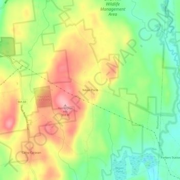
Nombre: Mapa topográfico Neale Place, altitud, relieve.
Altitud media: 300 m
Altitud mínima: 240 m
Altitud máxima: 366 m
Haz una donación
Equípate para tu próxima aventura:
Como asociado de Amazon, este sitio gana comisiones por las compras que califican, sin ningún costo adicional para usted.
Otros mapas topográficos
Haga clic en un mapa para ver su topografía, su altitud y su relieve.
Douglas
United States > Massachusetts > Worcester County
The principal elevations are Bald Hill, 711 feet (217 m), Wallum Pond Hill, 778 feet (237 m), Mount Ashworth, 713 feet (218 m), and Mount Daniel, 735 feet (224 m). There are numerous ponds in Douglas: Wallum Pond in the southwestern section, covering approximately 150 acres (61 ha); Badluck Pond in the western…
Altitud media: 173 m
Worcester
United States > Massachusetts > Worcester County
Worcester is known for being particularly snowy in the cold months, sometimes even experiencing autumn blizzards. The city averages 48.1 inches (1,220 mm) of precipitation a year, as well as an average of 72.9 inches (185 cm) of snowfall a season, receiving far more snow than coastal locations less than 40…
Altitud media: 186 m
Haz una donación
Equípate para tu próxima aventura:
Como asociado de Amazon, este sitio gana comisiones por las compras que califican, sin ningún costo adicional para usted.
Harvard
United States > Massachusetts > Worcester County
The eastern part of Harvard is on a large ridgeline. In 1931 Harvard College established the Oak Ridge Observatory at an elevation of 609 feet on Pinnacle Rd, the highest point between Mount Wachusett and the ocean.
Altitud media: 100 m
Haz una donación
Equípate para tu próxima aventura:
Como asociado de Amazon, este sitio gana comisiones por las compras que califican, sin ningún costo adicional para usted.
Haz una donación
Equípate para tu próxima aventura:
Como asociado de Amazon, este sitio gana comisiones por las compras que califican, sin ningún costo adicional para usted.
Worcester
United States > Massachusetts > Worcester County
Worcester is known for being particularly snowy in the cold months, sometimes even experiencing autumn blizzards. The city averages 48.1 inches (1,220 mm) of precipitation a year, as well as an average of 72.9 inches (185 cm) of snowfall a season, receiving far more snow than coastal locations less than 40…
Altitud media: 186 m
Westborough
United States > Massachusetts > Worcester County
According to the United States Census Bureau, the town has a total area of 21.6 square miles (56.0 km2), of which 20.5 square miles (53.1 km2) of it is land, and 1.1 square miles (2.8 km2) of it is water or 5.09 percent. Westborough contains the headwaters of the Sudbury and Assabet rivers. The town contains…
Altitud media: 113 m
Gardner
United States > Massachusetts > Worcester County
According to the United States Census Bureau, Gardner has a total area of 23.0 square miles (60 km2), of which 22.2 square miles (57 km2) is land and 0.8 square miles (2.1 km2), or 3.52%, is water. The city is situated on Crystal Lake. Its highest point is the summit of Reservoir Hill, close to the city…
Altitud media: 326 m
Haz una donación
Equípate para tu próxima aventura:
Como asociado de Amazon, este sitio gana comisiones por las compras que califican, sin ningún costo adicional para usted.
Haz una donación
Equípate para tu próxima aventura:
Como asociado de Amazon, este sitio gana comisiones por las compras que califican, sin ningún costo adicional para usted.
Haz una donación
Equípate para tu próxima aventura:
Como asociado de Amazon, este sitio gana comisiones por las compras que califican, sin ningún costo adicional para usted.
Haz una donación
Equípate para tu próxima aventura:
Como asociado de Amazon, este sitio gana comisiones por las compras que califican, sin ningún costo adicional para usted.
Uxbridge
United States > Massachusetts > Worcester County
The town is 30.4 square miles (79 km2), of which 0.8 square miles (2.1 km2), or 2.74%, is water. It is situated 39.77 miles (64.00 km) southwest of Boston, 16 miles (26 km) southeast of Worcester, and 20 miles (32 km) northwest of Providence. Elevations range from 200 feet (61 m) to 577 feet (176 m) above sea…
Altitud media: 116 m
Haz una donación
Equípate para tu próxima aventura:
Como asociado de Amazon, este sitio gana comisiones por las compras que califican, sin ningún costo adicional para usted.
Athol
United States > Massachusetts > Worcester County
According to the United States Census Bureau, the town has a total area of 33.4 square miles (86.5 km2), of which 32.6 square miles (84.4 km2) is land and 0.8 square miles (2.1 km2) (2.46%) is water. The town is drained mostly by the Millers River, which flows through the downtown area from northeast to west,…
Altitud media: 251 m
Haz una donación
Equípate para tu próxima aventura:
Como asociado de Amazon, este sitio gana comisiones por las compras que califican, sin ningún costo adicional para usted.
Ashburnham
United States > Massachusetts > Worcester County
According to the United States Census Bureau, the town has a total area of 41.0 square miles (106 km2), of which 38.7 square miles (100 km2) is land and 2.3 square miles (6.0 km2) (5.68%) is water. Ashburnham has two distinct topographical areas, hilly to the east and relatively flat high ground to the west.…
Altitud media: 345 m
Haz una donación
Equípate para tu próxima aventura:
Como asociado de Amazon, este sitio gana comisiones por las compras que califican, sin ningún costo adicional para usted.
Haz una donación
Equípate para tu próxima aventura:
Como asociado de Amazon, este sitio gana comisiones por las compras que califican, sin ningún costo adicional para usted.
Haz una donación
Equípate para tu próxima aventura:
Como asociado de Amazon, este sitio gana comisiones por las compras que califican, sin ningún costo adicional para usted.
Haz una donación
Equípate para tu próxima aventura:
Como asociado de Amazon, este sitio gana comisiones por las compras que califican, sin ningún costo adicional para usted.
Haz una donación
Equípate para tu próxima aventura:
Como asociado de Amazon, este sitio gana comisiones por las compras que califican, sin ningún costo adicional para usted.
Haz una donación
Equípate para tu próxima aventura:
Como asociado de Amazon, este sitio gana comisiones por las compras que califican, sin ningún costo adicional para usted.
Westborough
United States > Massachusetts > Worcester County
According to the United States Census Bureau, the town has a total area of 21.6 square miles (56.0 km2), of which 20.5 square miles (53.1 km2) of it is land, and 1.1 square miles (2.8 km2) of it is water or 5.09 percent. Westborough contains the headwaters of the Sudbury and Assabet rivers. The town contains…
Altitud media: 113 m
Athol
United States > Massachusetts > Worcester County
According to the United States Census Bureau, the town has a total area of 33.4 square miles (86.5 km2), of which 32.6 square miles (84.4 km2) is land and 0.8 square miles (2.1 km2) (2.46%) is water. The town is drained mostly by the Millers River, which flows through the downtown area from northeast to west,…
Altitud media: 256 m
Haz una donación
Equípate para tu próxima aventura:
Como asociado de Amazon, este sitio gana comisiones por las compras que califican, sin ningún costo adicional para usted.
Haz una donación
Equípate para tu próxima aventura:
Como asociado de Amazon, este sitio gana comisiones por las compras que califican, sin ningún costo adicional para usted.
Haz una donación
Equípate para tu próxima aventura:
Como asociado de Amazon, este sitio gana comisiones por las compras que califican, sin ningún costo adicional para usted.
Institute Park
United States > Massachusetts > Worcester County > Worcester > Belmont Hill
Altitud media: 170 m
Haz una donación
Equípate para tu próxima aventura:
Como asociado de Amazon, este sitio gana comisiones por las compras que califican, sin ningún costo adicional para usted.
Haz una donación
Equípate para tu próxima aventura:
Como asociado de Amazon, este sitio gana comisiones por las compras que califican, sin ningún costo adicional para usted.
Hadwen Park
United States > Massachusetts > Worcester County > Worcester > Heard Street
Altitud media: 166 m
Worcester
United States > Massachusetts > Worcester County
Worcester is known for being particularly snowy in the cold months, sometimes even experiencing intense autumn blizzards. The city averages 48.07 inches (1,220 mm) of precipitation a year, as well as an average of 64 inches (160 cm) of snowfall a season, receiving far more snow than coastal locations less than…
Altitud media: 186 m
Haz una donación
Equípate para tu próxima aventura:
Como asociado de Amazon, este sitio gana comisiones por las compras que califican, sin ningún costo adicional para usted.
Gardner
United States > Massachusetts > Worcester County
According to the United States Census Bureau, Gardner has a total area of 23.0 square miles (60 km2), of which 22.2 square miles (57 km2) is land and 0.8 square miles (2.1 km2), or 3.52%, is water. The city is situated on Crystal Lake. Its highest point is the summit of Reservoir Hill, close to the city…
Altitud media: 326 m
Haz una donación
Equípate para tu próxima aventura:
Como asociado de Amazon, este sitio gana comisiones por las compras que califican, sin ningún costo adicional para usted.
Haz una donación
Equípate para tu próxima aventura:
Como asociado de Amazon, este sitio gana comisiones por las compras que califican, sin ningún costo adicional para usted.
Haz una donación
Equípate para tu próxima aventura:
Como asociado de Amazon, este sitio gana comisiones por las compras que califican, sin ningún costo adicional para usted.
Uxbridge
United States > Massachusetts > Worcester County
The town is 30.4 square miles (79 km2), of which 0.8 square miles (2.1 km2), or 2.74%, is water. It is situated 39.77 miles (64.00 km) southwest of Boston, 16 miles (26 km) southeast of Worcester, and 20 miles (32 km) northwest of Providence. Elevations range from 200 feet (61 m) to 577 feet (176 m) above sea…
Altitud media: 115 m
Haz una donación
Equípate para tu próxima aventura:
Como asociado de Amazon, este sitio gana comisiones por las compras que califican, sin ningún costo adicional para usted.