
Haz una donación
Equípate para tu próxima aventura:
Como asociado de Amazon, este sitio gana comisiones por las compras que califican, sin ningún costo adicional para usted.
Mapa topográfico Westborough
Haga clic en el mapa para ver la altitud.
Haz una donación
Equípate para tu próxima aventura:
Como asociado de Amazon, este sitio gana comisiones por las compras que califican, sin ningún costo adicional para usted.
Westborough
According to the United States Census Bureau, the town has a total area of 21.6 square miles (56.0 km2), of which 20.5 square miles (53.1 km2) of it is land, and 1.1 square miles (2.8 km2) of it is water or 5.09 percent. Westborough contains the headwaters of the Sudbury and Assabet rivers. The town contains numerous bodies of water, including Lake Chauncy, George H. Nichols Reservoir (Mill Pond), Westboro Reservoir (Sandra Pond), Hocomonco Pond, and Cedar Swamp Pond. Lake Chauncy is open to swimming, boating, and fishing, and has a public beach open to residents of Westborough and Northborough during the summer months. The average elevation of the town is approximately 300 feet (91 m).
Haz una donación
Equípate para tu próxima aventura:
Como asociado de Amazon, este sitio gana comisiones por las compras que califican, sin ningún costo adicional para usted.
Acerca de este mapa
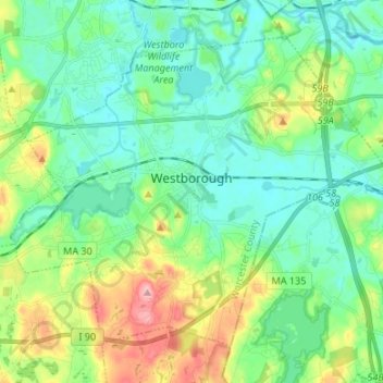
Nombre: Mapa topográfico Westborough, altitud, relieve.
Altitud media: 113 m
Altitud mínima: 76 m
Altitud máxima: 210 m
Haz una donación
Equípate para tu próxima aventura:
Como asociado de Amazon, este sitio gana comisiones por las compras que califican, sin ningún costo adicional para usted.
Otros mapas topográficos
Haga clic en un mapa para ver su topografía, su altitud y su relieve.
Central (Stanley) Woolen Mill District Park
United States > Massachusetts > Worcester County > Uxbridge
Altitud media: 80 m
Haz una donación
Equípate para tu próxima aventura:
Como asociado de Amazon, este sitio gana comisiones por las compras que califican, sin ningún costo adicional para usted.
Haz una donación
Equípate para tu próxima aventura:
Como asociado de Amazon, este sitio gana comisiones por las compras que califican, sin ningún costo adicional para usted.
Haz una donación
Equípate para tu próxima aventura:
Como asociado de Amazon, este sitio gana comisiones por las compras que califican, sin ningún costo adicional para usted.
Vernon Hill
United States > Massachusetts > Worcester County > Worcester > Quinsigamond Village
Altitud media: 162 m
Haz una donación
Equípate para tu próxima aventura:
Como asociado de Amazon, este sitio gana comisiones por las compras que califican, sin ningún costo adicional para usted.
Tatnuck
United States > Massachusetts > Worcester County > Worcester > Tatnuck Square
Altitud media: 221 m
Haz una donación
Equípate para tu próxima aventura:
Como asociado de Amazon, este sitio gana comisiones por las compras que califican, sin ningún costo adicional para usted.
Institute Park
United States > Massachusetts > Worcester County > Worcester > Belmont Hill
Altitud media: 170 m
Haz una donación
Equípate para tu próxima aventura:
Como asociado de Amazon, este sitio gana comisiones por las compras que califican, sin ningún costo adicional para usted.
Hadwen Park
United States > Massachusetts > Worcester County > Worcester > Heard Street
Altitud media: 166 m
Haz una donación
Equípate para tu próxima aventura:
Como asociado de Amazon, este sitio gana comisiones por las compras que califican, sin ningún costo adicional para usted.
Haz una donación
Equípate para tu próxima aventura:
Como asociado de Amazon, este sitio gana comisiones por las compras que califican, sin ningún costo adicional para usted.
Haz una donación
Equípate para tu próxima aventura:
Como asociado de Amazon, este sitio gana comisiones por las compras que califican, sin ningún costo adicional para usted.
Northbridge Center
United States > Massachusetts > Worcester County > Northbridge
Altitud media: 124 m
Haz una donación
Equípate para tu próxima aventura:
Como asociado de Amazon, este sitio gana comisiones por las compras que califican, sin ningún costo adicional para usted.
Phillipston Four Corners
United States > Massachusetts > Worcester County > Phillipston
Altitud media: 335 m
Haz una donación
Equípate para tu próxima aventura:
Como asociado de Amazon, este sitio gana comisiones por las compras que califican, sin ningún costo adicional para usted.
Haz una donación
Equípate para tu próxima aventura:
Como asociado de Amazon, este sitio gana comisiones por las compras que califican, sin ningún costo adicional para usted.
Haz una donación
Equípate para tu próxima aventura:
Como asociado de Amazon, este sitio gana comisiones por las compras que califican, sin ningún costo adicional para usted.
Haz una donación
Equípate para tu próxima aventura:
Como asociado de Amazon, este sitio gana comisiones por las compras que califican, sin ningún costo adicional para usted.
South Charlton Reservoir
United States > Massachusetts > Worcester County > Charlton > South Charlton
Altitud media: 203 m
Haz una donación
Equípate para tu próxima aventura:
Como asociado de Amazon, este sitio gana comisiones por las compras que califican, sin ningún costo adicional para usted.
Haz una donación
Equípate para tu próxima aventura:
Como asociado de Amazon, este sitio gana comisiones por las compras que califican, sin ningún costo adicional para usted.
Hadwen Arboretum
United States > Massachusetts > Worcester County > Worcester > Main South
Altitud media: 165 m
Martha Templeton Rock
United States > Massachusetts > Worcester County > Southborough
Altitud media: 95 m
Haz una donación
Equípate para tu próxima aventura:
Como asociado de Amazon, este sitio gana comisiones por las compras que califican, sin ningún costo adicional para usted.
Haz una donación
Equípate para tu próxima aventura:
Como asociado de Amazon, este sitio gana comisiones por las compras que califican, sin ningún costo adicional para usted.