
Haz una donación
Equípate para tu próxima aventura:
Como asociado de Amazon, este sitio gana comisiones por las compras que califican, sin ningún costo adicional para usted.
Mapa topográfico Athol
Haga clic en el mapa para ver la altitud.
Haz una donación
Equípate para tu próxima aventura:
Como asociado de Amazon, este sitio gana comisiones por las compras que califican, sin ningún costo adicional para usted.
Athol
According to the United States Census Bureau, the town has a total area of 33.4 square miles (86.5 km2), of which 32.6 square miles (84.4 km2) is land and 0.8 square miles (2.1 km2) (2.46%) is water. The town is drained mostly by the Millers River, which flows through the downtown area from northeast to west, towards the Connecticut River. The Tully River flows into the Millers within town, and many other streams cross the town. Parts of Tully Lake and Lake Rohunta lie within town, as does Lake Ellis and several other small ponds. The soil of Athol is rough and stony, and the terrain is wooded and hilly, with elevations ranging from 500 feet (150 m) above sea level at the edge of the Millers River to 1,282 feet (391 m) at the top of Pratt Hill near the Bearsden Forest. A large portion of the Millers River Wildlife Management Area lies within town, as does a small portion of Petersham State Forest.
Haz una donación
Equípate para tu próxima aventura:
Como asociado de Amazon, este sitio gana comisiones por las compras que califican, sin ningún costo adicional para usted.
Acerca de este mapa
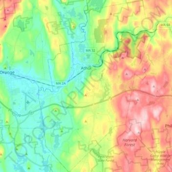
Nombre: Mapa topográfico Athol, altitud, relieve.
Lugar: Athol, Worcester County, Massachusetts, 01331, United States (42.51344 -72.27666 42.64651 -72.15437)
Altitud media: 256 m
Altitud mínima: 148 m
Altitud máxima: 417 m
Haz una donación
Equípate para tu próxima aventura:
Como asociado de Amazon, este sitio gana comisiones por las compras que califican, sin ningún costo adicional para usted.
Otros mapas topográficos
Haga clic en un mapa para ver su topografía, su altitud y su relieve.
Central (Stanley) Woolen Mill District Park
United States > Massachusetts > Worcester County > Uxbridge
Altitud media: 80 m
Haz una donación
Equípate para tu próxima aventura:
Como asociado de Amazon, este sitio gana comisiones por las compras que califican, sin ningún costo adicional para usted.
Haz una donación
Equípate para tu próxima aventura:
Como asociado de Amazon, este sitio gana comisiones por las compras que califican, sin ningún costo adicional para usted.
Haz una donación
Equípate para tu próxima aventura:
Como asociado de Amazon, este sitio gana comisiones por las compras que califican, sin ningún costo adicional para usted.
Vernon Hill
United States > Massachusetts > Worcester County > Worcester > Quinsigamond Village
Altitud media: 162 m
Haz una donación
Equípate para tu próxima aventura:
Como asociado de Amazon, este sitio gana comisiones por las compras que califican, sin ningún costo adicional para usted.
Tatnuck
United States > Massachusetts > Worcester County > Worcester > Tatnuck Square
Altitud media: 221 m
Haz una donación
Equípate para tu próxima aventura:
Como asociado de Amazon, este sitio gana comisiones por las compras que califican, sin ningún costo adicional para usted.
Institute Park
United States > Massachusetts > Worcester County > Worcester > Belmont Hill
Altitud media: 170 m
Haz una donación
Equípate para tu próxima aventura:
Como asociado de Amazon, este sitio gana comisiones por las compras que califican, sin ningún costo adicional para usted.
Hadwen Park
United States > Massachusetts > Worcester County > Worcester > Heard Street
Altitud media: 166 m
Haz una donación
Equípate para tu próxima aventura:
Como asociado de Amazon, este sitio gana comisiones por las compras que califican, sin ningún costo adicional para usted.
Haz una donación
Equípate para tu próxima aventura:
Como asociado de Amazon, este sitio gana comisiones por las compras que califican, sin ningún costo adicional para usted.
Haz una donación
Equípate para tu próxima aventura:
Como asociado de Amazon, este sitio gana comisiones por las compras que califican, sin ningún costo adicional para usted.
Northbridge Center
United States > Massachusetts > Worcester County > Northbridge
Altitud media: 124 m
Haz una donación
Equípate para tu próxima aventura:
Como asociado de Amazon, este sitio gana comisiones por las compras que califican, sin ningún costo adicional para usted.
Phillipston Four Corners
United States > Massachusetts > Worcester County > Phillipston
Altitud media: 335 m
Haz una donación
Equípate para tu próxima aventura:
Como asociado de Amazon, este sitio gana comisiones por las compras que califican, sin ningún costo adicional para usted.
Haz una donación
Equípate para tu próxima aventura:
Como asociado de Amazon, este sitio gana comisiones por las compras que califican, sin ningún costo adicional para usted.
Haz una donación
Equípate para tu próxima aventura:
Como asociado de Amazon, este sitio gana comisiones por las compras que califican, sin ningún costo adicional para usted.
Haz una donación
Equípate para tu próxima aventura:
Como asociado de Amazon, este sitio gana comisiones por las compras que califican, sin ningún costo adicional para usted.
South Charlton Reservoir
United States > Massachusetts > Worcester County > Charlton > South Charlton
Altitud media: 203 m
Haz una donación
Equípate para tu próxima aventura:
Como asociado de Amazon, este sitio gana comisiones por las compras que califican, sin ningún costo adicional para usted.
Haz una donación
Equípate para tu próxima aventura:
Como asociado de Amazon, este sitio gana comisiones por las compras que califican, sin ningún costo adicional para usted.
Hadwen Arboretum
United States > Massachusetts > Worcester County > Worcester > Main South
Altitud media: 165 m
Martha Templeton Rock
United States > Massachusetts > Worcester County > Southborough
Altitud media: 95 m
Haz una donación
Equípate para tu próxima aventura:
Como asociado de Amazon, este sitio gana comisiones por las compras que califican, sin ningún costo adicional para usted.
Haz una donación
Equípate para tu próxima aventura:
Como asociado de Amazon, este sitio gana comisiones por las compras que califican, sin ningún costo adicional para usted.