
Mapa topográfico Leavenworth
Mapa interactivo
Haga clic en el mapa para ver la altitud.
Acerca de este mapa
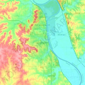
Nombre: Mapa topográfico Leavenworth, altitud, relieve.
Lugar: Leavenworth, Leavenworth County, Kansas, United States (39.23071 -94.96500 39.39245 -94.88074)
Altitud media: 268 m
Altitud mínima: 225 m
Altitud máxima: 345 m
Otros mapas topográficos
Haga clic en un mapa para ver su topografía, su altitud y su relieve.
Leavenworth
United States > Kansas > Leavenworth County > Leavenworth
Leavenworth is located at 39°18′40″N 94°55′21″W / 39.31111°N 94.92250°W / 39.31111; -94.92250 (39.3111112, −94.9224637) at an elevation of 840 feet (256 m).[5] Located in northeastern Kansas at the junction of U.S. Route 73 and Kansas Highway 92 (K-92), Leavenworth is 25 mi (40 km)…
Altitud media: 277 m