
Mapa topográfico Waltham
Mapa interactivo
Haga clic en el mapa para ver la altitud.
Acerca de este mapa
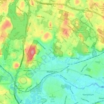
Nombre: Mapa topográfico Waltham, altitud, relieve.
Lugar: Waltham, Middlesex County, Massachusetts, United States (42.35364 -71.28603 42.42445 -71.19417)
Altitud media: 48 m
Altitud mínima: 2 m
Altitud máxima: 137 m
Otros mapas topográficos
Haga clic en un mapa para ver su topografía, su altitud y su relieve.
Medford Hillside
United States > Massachusetts > Middlesex County > Medford > West Medford
Altitud media: 13 m
Hobbs Road
United States > Massachusetts > Middlesex County > Wayland > Cochituate
Altitud media: 66 m
Cambridge
United States > Massachusetts > Middlesex County > Cambridge
Cambridge obtains water from Hobbs Brook (in Lincoln and Waltham) and Stony Brook (Waltham and Weston), as well as an emergency connection to the Massachusetts Water Resources Authority. The city owns over 1,200 acres (486 ha) of land in other towns that includes these reservoirs and portions of their…
Altitud media: 31 m
Weston Station
United States > Massachusetts > Middlesex County > Weston > Weston Station
Altitud media: 55 m
Newton
United States > Massachusetts > Middlesex County > Newton
Newton has grown around a formation of seven hills. "The general features of Newton are not without interest. Seven principal elevations mark its surface, like the seven hills of ancient Rome, with the difference that the seven hills of Newton are much more distinct than the seven hills of Rome: Nonantum Hill,…
Altitud media: 43 m