
Mapa topográfico Laurens County
Mapa interactivo
Haga clic en el mapa para ver la altitud.
Acerca de este mapa
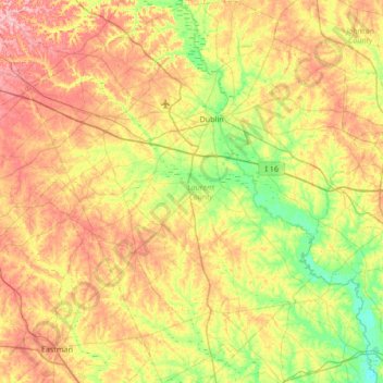
Nombre: Mapa topográfico Laurens County, altitud, relieve.
Lugar: Laurens County, Georgia, United States (32.14742 -83.22654 32.71576 -82.63313)
Altitud media: 86 m
Altitud mínima: 29 m
Altitud máxima: 159 m
Otros mapas topográficos
Haga clic en un mapa para ver su topografía, su altitud y su relieve.
Vinings
United States > Georgia > Cobb County
Vinings features a varied topography characterized by rolling hills and lush, wooded areas that provide a picturesque backdrop to the community. The area is nestled alongside the Chattahoochee River, which contributes to the gentle slopes and valleys that define the landscape. Elevations in Vinings typically…
Altitud media: 281 m
Stone Mountain
United States > Georgia > DeKalb County
The park is owned by the state of Georgia and is currently managed by Herschend Family Entertainment. At its summit, the elevation is 1,686 feet (514 m) above sea level and 825 feet (251 m) above the surrounding area. Stone Mountain is well known for not only its geology, but also the enormous rock relief on…
Altitud media: 299 m
Georgia International Horse Park
United States > Georgia > Rockdale County > Conyers
Altitud media: 217 m
Blood Mountain
United States > Georgia > Union County
Blood Mountain is the highest peak on the Georgia section of the Appalachian Trail and the sixth-tallest mountain in Georgia, with an elevation of 4,458 feet (1,359 m). It is located on the border of Lumpkin County with Union County and is within the boundaries of the Chattahoochee National Forest and the…
Altitud media: 1.048 m
Palmetto Pines Mobile Home Park
United States > Georgia > Camden County > Kingsland
Altitud media: 6 m
Pine Ridge Country Club Estates
United States > Georgia > Gwinnett County > Lawrenceville
Altitud media: 323 m