
Haz una donación
Equípate para tu próxima aventura:
Como asociado de Amazon, este sitio gana comisiones por las compras que califican, sin ningún costo adicional para usted.
Mapa topográfico Dyke
Haga clic en el mapa para ver la altitud.
Haz una donación
Equípate para tu próxima aventura:
Como asociado de Amazon, este sitio gana comisiones por las compras que califican, sin ningún costo adicional para usted.
Acerca de este mapa
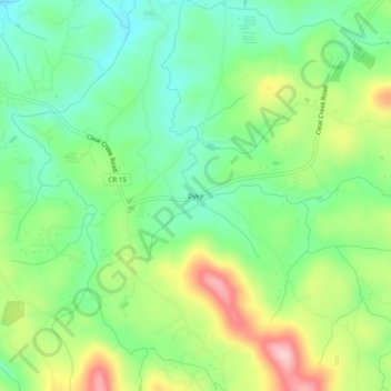
Nombre: Mapa topográfico Dyke, altitud, relieve.
Lugar: Dyke, Gilmer County, Georgia, 30636, United States (34.57981 -84.43159 34.61981 -84.39159)
Altitud media: 508 m
Altitud mínima: 435 m
Altitud máxima: 633 m
Haz una donación
Equípate para tu próxima aventura:
Como asociado de Amazon, este sitio gana comisiones por las compras que califican, sin ningún costo adicional para usted.
Otros mapas topográficos
Haga clic en un mapa para ver su topografía, su altitud y su relieve.
Ellijay
United States > Georgia > Gilmer County
Ellijay sits within a rugged and mountainous terrain, characterized by rolling hills, deep valleys, and ridgelines that are part of the larger Appalachian Mountain system. The area has an average elevation of about 1,390 feet, though nearby peaks like Walnut Mountain rise to elevations over 2,500 feet. The…
Altitud media: 424 m
Haz una donación
Equípate para tu próxima aventura:
Como asociado de Amazon, este sitio gana comisiones por las compras que califican, sin ningún costo adicional para usted.
Ellijay
United States > Georgia > Gilmer County
Ellijay lies within the Humid subtropical climate zone along with the majority of the rest of the Southeastern United States. The highest elevations in the surrounding region reside in the oceanic climate. Ellijay enjoys cool winters and warm summers, but neither would be considered extreme due to its slightly…
Altitud media: 424 m
Ellijay
United States > Georgia > Gilmer County
Ellijay lies within the Humid subtropical climate zone along with the majority of the rest of the southeastern United States. The highest elevations in the surrounding region reside in the Subtropical highland climate. Ellijay enjoys cool winters and warm summers, but neither would be considered extreme thanks…
Altitud media: 424 m