
Haz una donación
Equípate para tu próxima aventura:
Como asociado de Amazon, este sitio gana comisiones por las compras que califican, sin ningún costo adicional para usted.
Mapa topográfico Ellijay
Haga clic en el mapa para ver la altitud.
Haz una donación
Equípate para tu próxima aventura:
Como asociado de Amazon, este sitio gana comisiones por las compras que califican, sin ningún costo adicional para usted.
Ellijay
Ellijay sits within a rugged and mountainous terrain, characterized by rolling hills, deep valleys, and ridgelines that are part of the larger Appalachian Mountain system. The area has an average elevation of about 1,390 feet, though nearby peaks like Walnut Mountain rise to elevations over 2,500 feet. The landscape is shaped by a series of steep ridges and creeks, with significant features such as the Cartecay and Ellijay Rivers weaving through the valleys. The region's topography provides stunning vistas and is ideal for outdoor activities like hiking and river rafting, with the mountains offering both a natural barrier and a unique ecological environment. This combination of elevation and terrain makes Ellijay a prime destination for nature lovers and adventure seekers.
Haz una donación
Equípate para tu próxima aventura:
Como asociado de Amazon, este sitio gana comisiones por las compras que califican, sin ningún costo adicional para usted.
Acerca de este mapa
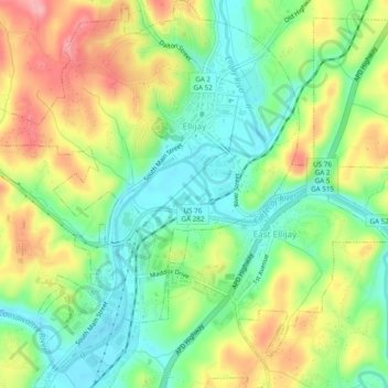
Nombre: Mapa topográfico Ellijay, altitud, relieve.
Lugar: Ellijay, Gilmer County, Georgia, 30540, United States (34.66807 -84.51152 34.70778 -84.46965)
Altitud media: 424 m
Altitud mínima: 373 m
Altitud máxima: 496 m
Haz una donación
Equípate para tu próxima aventura:
Como asociado de Amazon, este sitio gana comisiones por las compras que califican, sin ningún costo adicional para usted.
Otros mapas topográficos
Haga clic en un mapa para ver su topografía, su altitud y su relieve.
Haz una donación
Equípate para tu próxima aventura:
Como asociado de Amazon, este sitio gana comisiones por las compras que califican, sin ningún costo adicional para usted.