
Mapa topográfico Windermere
Haga clic en el mapa para ver la altitud.
Windermere
There is debate as to whether the stretch of water between Newby Bridge and Lakeside at the southern end of the lake should be considered part of Windermere, or a navigable stretch of the River Leven. This affects the stated length of the lake, which is 11.23 miles (18.07 km) long if measured from the bridge at Newby Bridge,[10] or 10.5 miles (16.9 km) if measured from Lakeside[citation needed]. The lake varies in width up to a maximum of 1 mile (1.6 km), and covers an area of 14.73 km2 (5.69 sq mi).[10] With a maximum depth of 66.7 m (219 ft) and an elevation above sea level of 39 m (128 ft), the lowest point of the lake bed is well below sea level.[10]
Acerca de este mapa
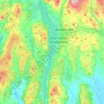
Nombre: Mapa topográfico Windermere, altitud, relieve.
Altitud media: 132 m
Altitud mínima: 3 m
Altitud máxima: 478 m
Otros mapas topográficos
Haga clic en un mapa para ver su topografía, su altitud y su relieve.
Storrs
United Kingdom > England > Cumbria > South Lakeland > Bowness-on-Windermere
Altitud media: 93 m