Geolocalizar

Mapa topográfico Storrs

Haga clic en el mapa para ver la altitud.

Acerca de este mapa

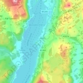
Nombre: Mapa topográfico Storrs, altitud, relieve.

Lugar: Storrs, Windermere, Bowness-on-Windermere, South Lakeland, Cumbria, England, LA23 3QR, United Kingdom (54.31994 -2.95243 54.35994 -2.91243)

Altitud media: 93 m

Altitud mínima: 36 m

Altitud máxima: 226 m

Otros mapas topográficos

Haga clic en un mapa para ver su topografía, su altitud y su relieve.

Windermere

United Kingdom > England > Cumbria > South Lakeland > Bowness-on-Windermere

There is debate as to whether the stretch of water between Newby Bridge and Lakeside at the southern end of the lake should be considered part of Windermere, or a navigable stretch of the River Leven. This affects the stated length of the lake, which is 11.23 miles (18.07 km) long if measured from the bridge…

Altitud media: 132 m

Equípate para tu próxima aventura:

🚲Bombas de Aire Portátiles - Inflado rápido en mitad de la ruta
🥾Botas de Senderismo para Hombre - Calzado robusto y protector para rutas por terrenos difíciles
🧴Cremas Anti-rozaduras - Protección para pies y muslos en rutas largas
🛠️Multiherramientas para Bici - Ajustes rápidos para no detener tu aventura
👟Zapatillas de Trail Running Hombre - Calzado ligero y con tracción para correr por senderos

Como asociado de Amazon, este sitio gana comisiones por las compras que califican, sin ningún costo adicional para usted.