
Mapa topográfico Saint Ansgar
Mapa interactivo
Haga clic en el mapa para ver la altitud.
Acerca de este mapa
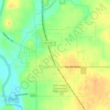
Nombre: Mapa topográfico Saint Ansgar, altitud, relieve.
Lugar: Saint Ansgar, Mitchell County, Iowa, United States (43.37110 -92.93145 43.39166 -92.90523)
Altitud media: 354 m
Altitud mínima: 335 m
Altitud máxima: 369 m
Otros mapas topográficos
Haga clic en un mapa para ver su topografía, su altitud y su relieve.
Osage
United States > Iowa > Mitchell County
Osage, Mitchell County, Iowa, 50461, United States
Altitud media: 354 m
Mitchell
United States > Iowa > Mitchell County
Mitchell, Mitchell County, Iowa, United States
Altitud media: 357 m
Stacyville
United States > Iowa > Mitchell County > Stacyville
Stacyville, Mitchell County, Iowa, 50476, United States
Altitud media: 372 m
Stacyville
United States > Iowa > Mitchell County
Stacyville, Mitchell County, Iowa, United States
Altitud media: 370 m