
Mapa topográfico Ghanzi District
Mapa interactivo
Haga clic en el mapa para ver la altitud.
Acerca de este mapa
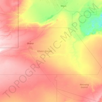
Nombre: Mapa topográfico Ghanzi District, altitud, relieve.
Lugar: Ghanzi District, Botswana (-23.32233 19.99908 -20.99537 25.44662)
Altitud media: 1.071 m
Altitud mínima: 902 m
Altitud máxima: 1.391 m
In the west, Ghanzi borders the Omaheke Region of Namibia. Domestically, it borders the following districts: North-West on the north, Central on the east, Kweneng on the southeast, Kgalagadi on the south. Ghanzi is traversed by the northwesterly line of equal latitude and longitude. This region is largely covered by the Kalahari Desert, some of which is also covered by the Makgadikgadi Pans, a large seasonal wetland. The Makgadigadi was one of the Earth's largest lakes during the Pleistocene, but currently provides a vast summer wetland to support tens of thousands of migrating flamingos in the rainy summer season. The largest village in the district is the capital Ghanzi with a population of 9,934 according to the 2001 census, which is five times more than the second-largest village Ncojane has. Most part of Botswana has tableland slopes sliding from east to west. The region has an average elevation of around 550 m (1,800 ft) above the mean sea level. The vegetation type is Savannah, with tall grasses, bushes and trees on the eastern sides, but it is arid in the Central and Western regions. The annual precipitation is around 25 cm (9.8 in), most of which is received during the summer season from November to May. Most of the rivers in the region are seasonal which are prone to flash floods, being the most prominent. The tourist and game reserves in the region are Ghanzi, Central Kalahari Game Reserve, Deception Valley, Ghanzi Craft, Kgalagadi Transfrontier Park, Khutse Game Reserve and Kuru Museum and Cultural Centre.
Otros mapas topográficos
Haga clic en un mapa para ver su topografía, su altitud y su relieve.
Ramatlabama
Ramatlabama, Southern District, Botswana
Altitud media: 1.279 m
Phakalane
Botswana > South-East District > Phakalane
Phakalane, South-East District, Botswana
Altitud media: 987 m
Kgalagadi Transfrontier Park
Kgalagadi Transfrontier Park, Kgalagadi District, Botswana
Altitud media: 1.021 m
Maun
Botswana > North-West District > Maun
Maun, North-West District, P.O. BOX 217, Botswana
Altitud media: 942 m
Gaborone Dam
Botswana > South-East District > Gaborone
Gaborone Dam, Gaborone, South-East District, Botswana
Altitud media: 992 m
Karakubis
Botswana > Ghanzi District > Karakubis
Karakubis, Ghanzi District, Botswana
Altitud media: 1.216 m
Shoshong
Botswana > Central District > Shoshong
Shoshong, Central District, Botswana
Altitud media: 1.115 m
Chobe National Park
Chobe National Park, Nogatsaa - Savuti, Chobe District, Botswana
Altitud media: 964 m
Kalahari Desert
Kalahari Desert, Ghanzi District, Botswana
Altitud media: 1.168 m
Lotlhakane
Botswana > Southern District > Lotlhakane
Lotlhakane, Southern District, Botswana
Altitud media: 1.188 m
Letlhakane
Botswana > Central District > Letlhakane
Letlhakane, Central District, NULL, Botswana
Altitud media: 990 m
Ngotwane River
Botswana > Kgatleng District > Mochudi
Ngotwane River, Mochudi, Kgatleng District, 721, Botswana
Altitud media: 937 m