
Mapa topográfico Central District
Mapa interactivo
Haga clic en el mapa para ver la altitud.
Acerca de este mapa
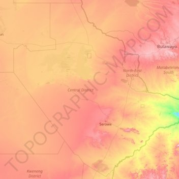
Nombre: Mapa topográfico Central District, altitud, relieve.
Lugar: Central District, Botswana (-23.96232 23.88413 -19.00003 29.37389)
Altitud media: 1.006 m
Altitud mínima: 576 m
Altitud máxima: 1.782 m
Most part of Botswana has tableland slopes sliding from east to west. The region has an average elevation of around 915 m (3,002 ft) above the mean sea level. The vegetation type is Savannah, with tall grasses, bushes and trees. The annual precipitation is around 65 cm (26 in), most of which is received during the summer season from November to May. Most of the rivers in the region are seasonal, with Limpopo River, which are prone to flash floods, being the most prominent. There are conflicts between agricultural expansion and protection of indigenous wildlife within the Central District. There are several seasonal rivers in the district including the Boteti River and the Lepashe River, whose flows in the rainy season reach the Makgadikgadi Pans.
Otros mapas topográficos
Haga clic en un mapa para ver su topografía, su altitud y su relieve.
Ramatlabama
Ramatlabama, Southern District, Botswana
Altitud media: 1.279 m
Phakalane
Botswana > South-East District > Phakalane
Phakalane, South-East District, Botswana
Altitud media: 987 m
Kgalagadi Transfrontier Park
Kgalagadi Transfrontier Park, Kgalagadi District, Botswana
Altitud media: 1.021 m
Maun
Botswana > North-West District > Maun
Maun, North-West District, P.O. BOX 217, Botswana
Altitud media: 942 m
Gaborone Dam
Botswana > South-East District > Gaborone
Gaborone Dam, Gaborone, South-East District, Botswana
Altitud media: 992 m
Karakubis
Botswana > Ghanzi District > Karakubis
Karakubis, Ghanzi District, Botswana
Altitud media: 1.216 m
Shoshong
Botswana > Central District > Shoshong
Shoshong, Central District, Botswana
Altitud media: 1.115 m
Chobe National Park
Chobe National Park, Nogatsaa - Savuti, Chobe District, Botswana
Altitud media: 964 m
Kalahari Desert
Kalahari Desert, Ghanzi District, Botswana
Altitud media: 1.168 m
Lotlhakane
Botswana > Southern District > Lotlhakane
Lotlhakane, Southern District, Botswana
Altitud media: 1.188 m
Letlhakane
Botswana > Central District > Letlhakane
Letlhakane, Central District, NULL, Botswana
Altitud media: 990 m
Ngotwane River
Botswana > Kgatleng District > Mochudi
Ngotwane River, Mochudi, Kgatleng District, 721, Botswana
Altitud media: 937 m