
Haz una donación
Equípate para tu próxima aventura:
Como asociado de Amazon, este sitio gana comisiones por las compras que califican, sin ningún costo adicional para usted.
Mapa topográfico Day Valley
Haga clic en el mapa para ver la altitud.
Haz una donación
Equípate para tu próxima aventura:
Como asociado de Amazon, este sitio gana comisiones por las compras que califican, sin ningún costo adicional para usted.
Acerca de este mapa
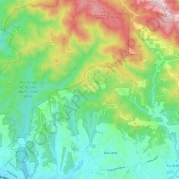
Nombre: Mapa topográfico Day Valley, altitud, relieve.
Lugar: Day Valley, Santa Cruz County, California, United States (36.98153 -121.90670 37.07711 -121.80439)
Altitud media: 335 m
Altitud mínima: 29 m
Altitud máxima: 897 m
Haz una donación
Equípate para tu próxima aventura:
Como asociado de Amazon, este sitio gana comisiones por las compras que califican, sin ningún costo adicional para usted.
Otros mapas topográficos
Haga clic en un mapa para ver su topografía, su altitud y su relieve.
Haz una donación
Equípate para tu próxima aventura:
Como asociado de Amazon, este sitio gana comisiones por las compras que califican, sin ningún costo adicional para usted.
Boulder Creek
United States > California > Santa Cruz County > Brookdale
Boulder Creek sits at the north end of the San Lorenzo Valley at the confluence of San Lorenzo River and Boulder Creek within the Santa Cruz Mountains, a Level IV ecoregion designated by the United States Environmental Protection Agency (EPA), an area surrounded by steep, redwood- and pine- covered hills…
Altitud media: 287 m
Shangri La Estates
United States > California > Santa Cruz County > Pleasure Point
Altitud media: 12 m
Haz una donación
Equípate para tu próxima aventura:
Como asociado de Amazon, este sitio gana comisiones por las compras que califican, sin ningún costo adicional para usted.
Scotts Valley
United States > California > Santa Cruz County
Approximately ten thousand years ago there was a lake in the lowest elevation of Scotts Valley, and Paleo Indians lived near its shores. Archeological excavations of site CA-SCR-177 in 1983 and 1987 support dates for human settlement of this area as between 9,000 and 12,000 years before present (YBP). The lake…
Altitud media: 203 m
Haz una donación
Equípate para tu próxima aventura:
Como asociado de Amazon, este sitio gana comisiones por las compras que califican, sin ningún costo adicional para usted.
Scotts Valley
United States > California > Santa Cruz County
Approximately ten thousand years ago there was a lake in the lowest elevation of Scotts Valley. Archeological excavations of site CA-SCR-177 (Scotts Valley Site) in 1983 and 1987 support dates for human settlement of this area as between 9,000 and 12,000 years before present (YBP). The lake drained during the…
Altitud media: 203 m
Haz una donación
Equípate para tu próxima aventura:
Como asociado de Amazon, este sitio gana comisiones por las compras que califican, sin ningún costo adicional para usted.
Haz una donación
Equípate para tu próxima aventura:
Como asociado de Amazon, este sitio gana comisiones por las compras que califican, sin ningún costo adicional para usted.
Boulder Creek
United States > California > Santa Cruz County
Boulder Creek sits at the north end of the San Lorenzo Valley at the confluence of San Lorenzo River and Boulder Creek within the Santa Cruz Mountains, a Level IV ecoregion designated by the United States Environmental Protection Agency (EPA), an area surrounded by steep, redwood- and pine- covered hills…
Altitud media: 287 m
Haz una donación
Equípate para tu próxima aventura:
Como asociado de Amazon, este sitio gana comisiones por las compras que califican, sin ningún costo adicional para usted.
Haz una donación
Equípate para tu próxima aventura:
Como asociado de Amazon, este sitio gana comisiones por las compras que califican, sin ningún costo adicional para usted.
Boulder Creek
United States > California > Santa Cruz County > Brookdale
Boulder Creek sits at the north end of the San Lorenzo Valley at the confluence of San Lorenzo River and Boulder Creek within the Santa Cruz Mountains, a Level IV ecoregion designated by the United States Environmental Protection Agency (EPA), an area surrounded by steep, redwood- and pine- covered hills…
Altitud media: 287 m
Haz una donación
Equípate para tu próxima aventura:
Como asociado de Amazon, este sitio gana comisiones por las compras que califican, sin ningún costo adicional para usted.