
Mapa topográfico Yamanouchi
Mapa interactivo
Haga clic en el mapa para ver la altitud.
Acerca de este mapa
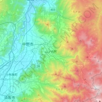
Nombre: Mapa topográfico Yamanouchi, altitud, relieve.
Lugar: Yamanouchi, Shimotakai County, Nagano Prefecture, Japan (36.66571 138.38338 36.82465 138.64215)
Altitud media: 942 m
Altitud mínima: 305 m
Altitud máxima: 2.303 m
Shimotakai District, in northern mountainous Nagano Prefecture, comprises Yamanouchi town, Kijimadaira Village, and Nozawaonsen Village. Yamanouchi is the largest of these. More than 90% of Yamanouchi is covered by mountains and forests. The town measures approximately 39 kilometers east-west and 12 kilometers north-south (266 square kilometers), and has an elevation ranging from 424 meters to 2341 meters. The surrounding area is known for its forest therapy.
Otros mapas topográficos
Haga clic en un mapa para ver su topografía, su altitud y su relieve.
Nozawaonsen
Nozawaonsen, Shimotakai County, Nagano Prefecture, Chubu Region, 389-2502, Japan
Altitud media: 710 m
Biwa Lake
Japan > Shimotakai County > Yamanouchi
Biwa Lake, Yamanouchi, Shimotakai County, Nagano Prefecture, Japan
Altitud media: 1.368 m