
Mapa topográfico Nozawaonsen
Mapa interactivo
Haga clic en el mapa para ver la altitud.
Acerca de este mapa
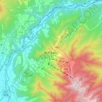
Nombre: Mapa topográfico Nozawaonsen, altitud, relieve.
Altitud media: 710 m
Altitud mínima: 278 m
Altitud máxima: 1.635 m
Nozawaonsen is located in mountainous northeastern Nagano Prefecture, about one hour's drive from Nagano City. To the south it borders Kijimadaira along the ridge of Mount Kenashi. To the west side the Chikuma River, the longest river in Japan, which forms a border of the village with the city of Iiyama. The north and the east borders Sakae village. The altitude of Nozawaonsen ranges from 300m above sea level at the lowest, to about 600m in the village, and 1,650m at the peak of Mount Kenashi.
Otros mapas topográficos
Haga clic en un mapa para ver su topografía, su altitud y su relieve.
Yamanouchi
Yamanouchi, Shimotakai County, Nagano Prefecture, Japan
Altitud media: 942 m
Biwa Lake
Japan > Shimotakai County > Yamanouchi
Biwa Lake, Yamanouchi, Shimotakai County, Nagano Prefecture, Japan
Altitud media: 1.368 m