
Mapa topográfico Flaxmere
Haga clic en el mapa para ver la altitud.
Acerca de este mapa
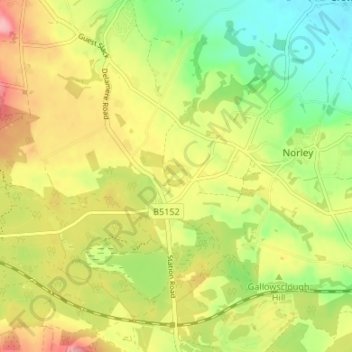
Nombre: Mapa topográfico Flaxmere, altitud, relieve.
Altitud media: 75 m
Altitud mínima: 14 m
Altitud máxima: 142 m
Otros mapas topográficos
Haga clic en un mapa para ver su topografía, su altitud y su relieve.
Countess of Chester Country Park
United Kingdom > England > Cheshire West and Chester > Chester
Altitud media: 21 m
Frodsham
United Kingdom > England > Cheshire West and Chester
Several faults run roughly northwest–southeast through the area, notably the Overton Fault, which roughly parallels the B5439 and B5152 roads, and the Frodsham Fault, which runs north from the vicinity of Crowmere to the mouth of the River Weaver. Both of these faults and others in the area downthrow to the…
Altitud media: 49 m
Bolesworth Fish Pond
United Kingdom > England > Cheshire West and Chester > Harthill > Broxton
Altitud media: 75 m
Wirral Country Park
United Kingdom > England > Cheshire West and Chester > Neston > Windle Hill
Altitud media: 49 m
Peckforton Castle
United Kingdom > England > Cheshire West and Chester > Beeston
Peckforton Castle stands in a wooded area near the northern extremity of Peckforton Hills at an elevation of 469.2 feet (143 m). The land falls steeply downwards to the north and the west of the castle, and the Sandstone Trail, a long-distance footpath, runs along the base of these slopes. The ruins of Beeston…
Altitud media: 83 m
Little Stanney
United Kingdom > England > Cheshire West and Chester > Ellesmere Port
Altitud media: 21 m
Dutton Small Lock (Disused)
United Kingdom > England > Cheshire West and Chester > Acton Bridge > Dutton
Altitud media: 28 m