
Mapa topográfico Bache
Haga clic en el mapa para ver la altitud.
Acerca de este mapa
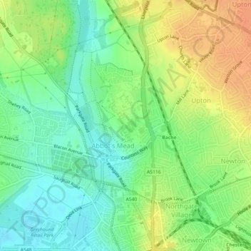
Nombre: Mapa topográfico Bache, altitud, relieve.
Lugar: Bache, Cheshire West and Chester, England, United Kingdom (53.20446 -2.90509 53.21330 -2.89438)
Altitud media: 21 m
Altitud mínima: 3 m
Altitud máxima: 42 m
Otros mapas topográficos
Haga clic en un mapa para ver su topografía, su altitud y su relieve.
Hapsford
United Kingdom > England > Cheshire West and Chester > Dunham on the Hill
Altitud media: 20 m
Dutton Locks
United Kingdom > England > Cheshire West and Chester > Acton Bridge > Dutton
Altitud media: 28 m
Countess of Chester Country Park
United Kingdom > England > Cheshire West and Chester > Chester
Altitud media: 21 m
Delamere Forest
United Kingdom > England > Cheshire West and Chester
This part of Delamere Forest is undulating in character, with elevations predominantly in the range 60–90 metres. It is composed of numerous hummocks and peatland basins, some of which are glacial in origin while others have been created by sand extraction. The basins form lakes and mosses (bogs) within the…
Altitud media: 90 m
Bolesworth Castle
United Kingdom > England > Cheshire West and Chester > Harthill > Broxton
Altitud media: 80 m
Bolesworth Fish Pond
United Kingdom > England > Cheshire West and Chester > Harthill > Broxton
Altitud media: 75 m
Wirral Country Park
United Kingdom > England > Cheshire West and Chester > Neston > Windle Hill
Altitud media: 49 m
Peckforton Castle
United Kingdom > England > Cheshire West and Chester > Beeston
Peckforton Castle stands in a wooded area near the northern extremity of Peckforton Hills at an elevation of 469.2 feet (143 m). The land falls steeply downwards to the north and the west of the castle, and the Sandstone Trail, a long-distance footpath, runs along the base of these slopes. The ruins of Beeston…
Altitud media: 83 m
Dutton Small Lock (Disused)
United Kingdom > England > Cheshire West and Chester > Acton Bridge > Dutton
Altitud media: 28 m
Stamford Bridge
United Kingdom > England > Cheshire West and Chester > Great Barrow
Altitud media: 24 m
Eddisbury Hill Fort
United Kingdom > England > Cheshire West and Chester > Delamere
Altitud media: 103 m
Bostock Green
United Kingdom > England > Cheshire West and Chester > Bostock Green
Altitud media: 36 m
Meadowbank
United Kingdom > England > Cheshire West and Chester > Winsford > Meadowbank
Altitud media: 40 m
Delamere Forest
United Kingdom > England > Cheshire West and Chester
This part of Delamere Forest is undulating in character, with elevations predominantly in the range 60–90 metres. It is composed of numerous hummocks and peatland basins, some of which are glacial in origin while others have been created by sand extraction. The basins form lakes and mosses (bogs) within the…
Altitud media: 90 m