
Haz una donación
Equípate para tu próxima aventura:
Como asociado de Amazon, este sitio gana comisiones por las compras que califican, sin ningún costo adicional para usted.
Mapa topográfico Taunton
Haga clic en el mapa para ver la altitud.
Haz una donación
Equípate para tu próxima aventura:
Como asociado de Amazon, este sitio gana comisiones por las compras que califican, sin ningún costo adicional para usted.
Taunton
Taunton has one major river, the Taunton River, along with its tributaries, including the Mill River and the Three Mile River. The highest point in the city is near its southwest corner, with an elevation of 207 feet (63 m) above sea level. Prospect Hill, rising over Lake Sabbatia north of the downtown, has an elevation of 197 feet (60 m).
Haz una donación
Equípate para tu próxima aventura:
Como asociado de Amazon, este sitio gana comisiones por las compras que califican, sin ningún costo adicional para usted.
Acerca de este mapa
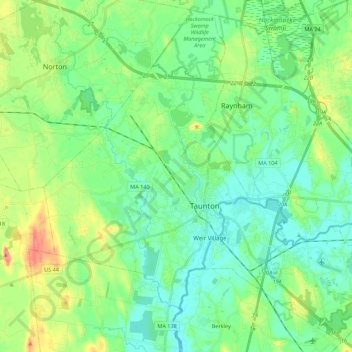
Nombre: Mapa topográfico Taunton, altitud, relieve.
Lugar: Taunton, Bristol County, Massachusetts, United States (41.83849 -71.19390 41.99318 -70.97372)
Altitud media: 21 m
Altitud mínima: -1 m
Altitud máxima: 72 m
Haz una donación
Equípate para tu próxima aventura:
Como asociado de Amazon, este sitio gana comisiones por las compras que califican, sin ningún costo adicional para usted.
Otros mapas topográficos
Haga clic en un mapa para ver su topografía, su altitud y su relieve.
Leonard and Marydee Flynn Cons Area
United States > Massachusetts > Bristol County > Mansfield
Altitud media: 39 m
Haz una donación
Equípate para tu próxima aventura:
Como asociado de Amazon, este sitio gana comisiones por las compras que califican, sin ningún costo adicional para usted.
Haz una donación
Equípate para tu próxima aventura:
Como asociado de Amazon, este sitio gana comisiones por las compras que califican, sin ningún costo adicional para usted.
Haz una donación
Equípate para tu próxima aventura:
Como asociado de Amazon, este sitio gana comisiones por las compras que califican, sin ningún costo adicional para usted.
Haz una donación
Equípate para tu próxima aventura:
Como asociado de Amazon, este sitio gana comisiones por las compras que califican, sin ningún costo adicional para usted.
Source Is Shapefile From Town
United States > Massachusetts > Bristol County > Mansfield > Robinsonville
Altitud media: 50 m
Daley Corner
United States > Massachusetts > Bristol County > Easton > North Easton
Altitud media: 47 m
Haz una donación
Equípate para tu próxima aventura:
Como asociado de Amazon, este sitio gana comisiones por las compras que califican, sin ningún costo adicional para usted.
Haz una donación
Equípate para tu próxima aventura:
Como asociado de Amazon, este sitio gana comisiones por las compras que califican, sin ningún costo adicional para usted.
Haz una donación
Equípate para tu próxima aventura:
Como asociado de Amazon, este sitio gana comisiones por las compras que califican, sin ningún costo adicional para usted.
Source Is Shapefile From Town
United States > Massachusetts > Bristol County > Mansfield > Robinsonville
Altitud media: 50 m
Haz una donación
Equípate para tu próxima aventura:
Como asociado de Amazon, este sitio gana comisiones por las compras que califican, sin ningún costo adicional para usted.