
Haz una donación
Equípate para tu próxima aventura:
Como asociado de Amazon, este sitio gana comisiones por las compras que califican, sin ningún costo adicional para usted.
Mapa topográfico North Dighton
Haga clic en el mapa para ver la altitud.
Haz una donación
Equípate para tu próxima aventura:
Como asociado de Amazon, este sitio gana comisiones por las compras que califican, sin ningún costo adicional para usted.
Acerca de este mapa
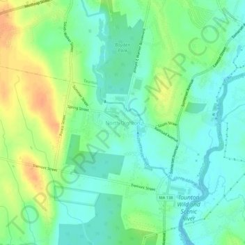
Nombre: Mapa topográfico North Dighton, altitud, relieve.
Altitud media: 14 m
Altitud mínima: -1 m
Altitud máxima: 36 m
Haz una donación
Equípate para tu próxima aventura:
Como asociado de Amazon, este sitio gana comisiones por las compras que califican, sin ningún costo adicional para usted.
Otros mapas topográficos
Haga clic en un mapa para ver su topografía, su altitud y su relieve.
New Bedford
United States > Massachusetts > Bristol County
New Bedford is located at 41°39′06″N 70°56′01″W / 41.651803°N 70.933705°W / 41.651803; -70.933705 (41.651803, −70.933705). According to the United States Census Bureau, the city has a total area of 24.1 square miles (62.5 km2). Of the total area, 20.0 square miles (51.8 km2) is land, and…
Altitud media: 21 m
Taunton
United States > Massachusetts > Bristol County
Taunton has one major river, the Taunton River, along with its tributaries, including the Mill River and the Three Mile River. The highest point in the city is near its southwest corner, with an elevation of 207 feet (63 m) above sea level. Prospect Hill, rising over Lake Sabbatia north of the downtown, has an…
Altitud media: 22 m
Haz una donación
Equípate para tu próxima aventura:
Como asociado de Amazon, este sitio gana comisiones por las compras que califican, sin ningún costo adicional para usted.
Fall River
United States > Massachusetts > Bristol County
Fall River was the only city on the East Coast of the United States to have had an exposed waterfall in part of its downtown area; it flowed less than 1⁄2 mile (0.8 km) into a sheltered harbor at the edge of downtown. Fall River has two large lakes (originally one lake) and a large portion of protected…
Altitud media: 32 m
Dartmouth
United States > Massachusetts > Bristol County
The highest point in the town is near its northwest corner, where the elevation rises to over 256 feet (78 m) above sea level north of Old Fall River Road.
Altitud media: 21 m
Haz una donación
Equípate para tu próxima aventura:
Como asociado de Amazon, este sitio gana comisiones por las compras que califican, sin ningún costo adicional para usted.
Leonard and Marydee Flynn Cons Area
United States > Massachusetts > Bristol County > Mansfield
Altitud media: 39 m
Acushnet
United States > Massachusetts > Bristol County
Acushnet lies along the Acushnet River and its tributaries, including the Keene River and Squinn Brook, which feed the New Bedford Reservoir, in turn feeding the Acushnet. The Acushnet River is the town line between it and New Bedford south of Main Street. There are several other ponds in the town, including…
Altitud media: 21 m
Haz una donación
Equípate para tu próxima aventura:
Como asociado de Amazon, este sitio gana comisiones por las compras que califican, sin ningún costo adicional para usted.
Haz una donación
Equípate para tu próxima aventura:
Como asociado de Amazon, este sitio gana comisiones por las compras que califican, sin ningún costo adicional para usted.
Fall River
United States > Massachusetts > Bristol County
Fall River was the only city on the East Coast of the United States to have had an exposed waterfall in part of its downtown area; it flowed less than 1⁄2 mile (0.8 km) into a sheltered harbor at the edge of downtown. Fall River has two large lakes (originally one lake) and a large portion of protected…
Altitud media: 32 m
New Bedford
United States > Massachusetts > Bristol County
New Bedford is located at 41°39′06″N 70°56′01″W / 41.651803°N 70.933705°W / 41.651803; -70.933705 (41.651803, −70.933705). According to the United States Census Bureau, the city has a total area of 24.1 square miles (62.5 km2). Of the total area, 20.0 square miles (51.8 km2) is land, and…
Altitud media: 21 m
Haz una donación
Equípate para tu próxima aventura:
Como asociado de Amazon, este sitio gana comisiones por las compras que califican, sin ningún costo adicional para usted.
Dighton
United States > Massachusetts > Bristol County
Dighton is bordered by Rehoboth to the west, Swansea to the southwest, Somerset to the south, the Taunton River and the town of Berkley to the east, and the city of Taunton to the north. In addition to being bordered by the Taunton River, it also is bordered by the Three Mile River, a tributary which empties…
Altitud media: 18 m
Haz una donación
Equípate para tu próxima aventura:
Como asociado de Amazon, este sitio gana comisiones por las compras que califican, sin ningún costo adicional para usted.
New Bedford
United States > Massachusetts > Bristol County
New Bedford is located at 41°39′06″N 70°56′01″W / 41.651803°N 70.933705°W / 41.651803; -70.933705 (41.651803, −70.933705). According to the United States Census Bureau, the city has a total area of 24.1 square miles (62.5 km2). Of the total area, 20.0 square miles (51.8 km2) is land, and…
Altitud media: 21 m
Acushnet
United States > Massachusetts > Bristol County
Acushnet lies along the Acushnet River and its tributaries, including the Keene River and Squinn Brook, which feed the New Bedford Reservoir, in turn feeding the Acushnet. The Acushnet River is the town line between it and New Bedford south of Main Street. There are several other ponds in the town, including…
Altitud media: 21 m
East Branch Westport River
United States > Massachusetts > Bristol County > Westport
Altitud media: 24 m
Haz una donación
Equípate para tu próxima aventura:
Como asociado de Amazon, este sitio gana comisiones por las compras que califican, sin ningún costo adicional para usted.
Taunton
United States > Massachusetts > Bristol County
Taunton has one major river, the Taunton River, along with its tributaries, including the Mill River and the Three Mile River. The highest point in the city is near its southwest corner, with an elevation of 207 feet (63 m) above sea level. Prospect Hill, rising over Lake Sabbatia north of the downtown, has an…
Altitud media: 21 m
Stetson-Piney Island Reserve
United States > Massachusetts > Bristol County > Dartmouth > Great Neck
Altitud media: 0 m
Haz una donación
Equípate para tu próxima aventura:
Como asociado de Amazon, este sitio gana comisiones por las compras que califican, sin ningún costo adicional para usted.
Source Is Shapefile From Town
United States > Massachusetts > Bristol County > Mansfield > Robinsonville
Altitud media: 50 m
Haz una donación
Equípate para tu próxima aventura:
Como asociado de Amazon, este sitio gana comisiones por las compras que califican, sin ningún costo adicional para usted.
Dartmouth
United States > Massachusetts > Bristol County
The highest point in the town is near its northwest corner, where the elevation rises to over 256 feet (78 m) above sea level north of Old Fall River Road.
Altitud media: 21 m
Haz una donación
Equípate para tu próxima aventura:
Como asociado de Amazon, este sitio gana comisiones por las compras que califican, sin ningún costo adicional para usted.
Source Is Shapefile From Town
United States > Massachusetts > Bristol County > Mansfield > Robinsonville
Altitud media: 50 m
Haz una donación
Equípate para tu próxima aventura:
Como asociado de Amazon, este sitio gana comisiones por las compras que califican, sin ningún costo adicional para usted.