
Haz una donación
Equípate para tu próxima aventura:
Como asociado de Amazon, este sitio gana comisiones por las compras que califican, sin ningún costo adicional para usted.
Mapa topográfico New Bedford
Haga clic en el mapa para ver la altitud.
Haz una donación
Equípate para tu próxima aventura:
Como asociado de Amazon, este sitio gana comisiones por las compras que califican, sin ningún costo adicional para usted.
New Bedford
New Bedford is located at 41°39′06″N 70°56′01″W / 41.651803°N 70.933705°W / 41.651803; -70.933705 (41.651803, −70.933705). According to the United States Census Bureau, the city has a total area of 24.1 square miles (62.5 km2). Of the total area, 20.0 square miles (51.8 km2) is land, and 4.1 square miles (10.7 km2), or 17.13%, is water. New Bedford is a coastal city, a seaport, bordered on the west by Dartmouth, on the north by Freetown, on the east by Acushnet and Fairhaven, and on the south by Buzzards Bay. From New Bedford's northern border with Freetown to the Buzzards Bay coast at Clark's Point the distance is approximately 14 miles (23 km). Across New Bedford east to west is a distance of about 2 miles (3.2 km). The highest point in the city is an unnamed hill crossed by Interstate 195 and Hathaway Road west of downtown, with an elevation greater than 180 feet (55 m) above sea level.
Haz una donación
Equípate para tu próxima aventura:
Como asociado de Amazon, este sitio gana comisiones por las compras que califican, sin ningún costo adicional para usted.
Acerca de este mapa
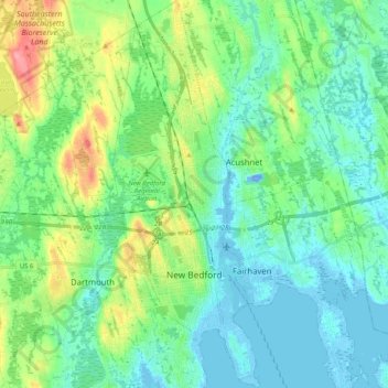
Nombre: Mapa topográfico New Bedford, altitud, relieve.
Lugar: New Bedford, Bristol County, Massachusetts, United States (41.59139 -70.97751 41.74467 -70.89939)
Altitud media: 21 m
Altitud mínima: -19 m
Altitud máxima: 80 m
Haz una donación
Equípate para tu próxima aventura:
Como asociado de Amazon, este sitio gana comisiones por las compras que califican, sin ningún costo adicional para usted.
Otros mapas topográficos
Haga clic en un mapa para ver su topografía, su altitud y su relieve.
Leonard and Marydee Flynn Cons Area
United States > Massachusetts > Bristol County > Mansfield
Altitud media: 39 m
Haz una donación
Equípate para tu próxima aventura:
Como asociado de Amazon, este sitio gana comisiones por las compras que califican, sin ningún costo adicional para usted.
Haz una donación
Equípate para tu próxima aventura:
Como asociado de Amazon, este sitio gana comisiones por las compras que califican, sin ningún costo adicional para usted.
Haz una donación
Equípate para tu próxima aventura:
Como asociado de Amazon, este sitio gana comisiones por las compras que califican, sin ningún costo adicional para usted.
Haz una donación
Equípate para tu próxima aventura:
Como asociado de Amazon, este sitio gana comisiones por las compras que califican, sin ningún costo adicional para usted.
Source Is Shapefile From Town
United States > Massachusetts > Bristol County > Mansfield > Robinsonville
Altitud media: 50 m
Daley Corner
United States > Massachusetts > Bristol County > Easton > North Easton
Altitud media: 47 m
Haz una donación
Equípate para tu próxima aventura:
Como asociado de Amazon, este sitio gana comisiones por las compras que califican, sin ningún costo adicional para usted.
Haz una donación
Equípate para tu próxima aventura:
Como asociado de Amazon, este sitio gana comisiones por las compras que califican, sin ningún costo adicional para usted.
Haz una donación
Equípate para tu próxima aventura:
Como asociado de Amazon, este sitio gana comisiones por las compras que califican, sin ningún costo adicional para usted.
Source Is Shapefile From Town
United States > Massachusetts > Bristol County > Mansfield > Robinsonville
Altitud media: 50 m
Haz una donación
Equípate para tu próxima aventura:
Como asociado de Amazon, este sitio gana comisiones por las compras que califican, sin ningún costo adicional para usted.