
Haz una donación
Equípate para tu próxima aventura:
Como asociado de Amazon, este sitio gana comisiones por las compras que califican, sin ningún costo adicional para usted.
Mapa topográfico Columbia Plateau
Haga clic en el mapa para ver la altitud.
Haz una donación
Equípate para tu próxima aventura:
Como asociado de Amazon, este sitio gana comisiones por las compras que califican, sin ningún costo adicional para usted.
Acerca de este mapa
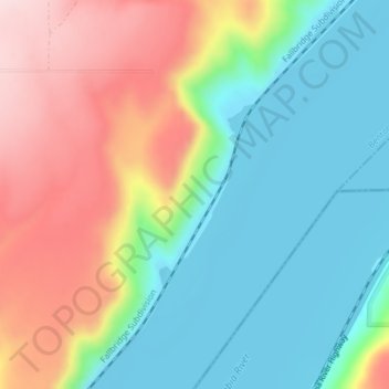
Nombre: Mapa topográfico Columbia Plateau, altitud, relieve.
Lugar: Columbia Plateau, Benton County, Washington, United States (45.99953 -119.00144 45.99963 -119.00134)
Altitud media: 221 m
Altitud mínima: 102 m
Altitud máxima: 417 m
Haz una donación
Equípate para tu próxima aventura:
Como asociado de Amazon, este sitio gana comisiones por las compras que califican, sin ningún costo adicional para usted.
Otros mapas topográficos
Haga clic en un mapa para ver su topografía, su altitud y su relieve.
Kennewick
United States > Washington > Benton County
Native Americans populated the area around modern-day Kennewick for millennia before being discovered and settled by European descendants. These inhabitants consisted of people from the Umatilla, Wanapum, Nez Perce, and Yakama tribes. Kennewick's low elevation helped to moderate winter temperatures. On top of…
Altitud media: 157 m
Richland
United States > Washington > Benton County
According to the United States Census Bureau, the city has a total area of 39.11 square miles (101.29 km2), of which, 35.72 square miles (92.51 km2) is land and 3.39 square miles (8.78 km2) is water. Elevation at the airport is 120 m (390 ft).
Altitud media: 164 m
Haz una donación
Equípate para tu próxima aventura:
Como asociado de Amazon, este sitio gana comisiones por las compras que califican, sin ningún costo adicional para usted.
West Richland
United States > Washington > Benton County
The original people of the region were the Chemnapum Indians (closely related to the Wanapum tribe), living near the mouth of the Yakima River. Lewis and Clark passed through the area in 1805, and an expedition of the Army Corps of Topographical Engineers headed by Robert E Johnson mapped the Yakima Valley in…
Altitud media: 146 m
Richland
United States > Washington > Benton County
According to the United States Census Bureau, the city has a total area of 39.11 square miles (101.29 km2), of which, 35.72 square miles (92.51 km2) is land and 3.39 square miles (8.78 km2) is water. Elevation at the airport is 120 m (390 ft).
Altitud media: 164 m
West Richland
United States > Washington > Benton County
The original people of the region were the Chemnapum Indians (closely related to the Wanapum tribe), living near the mouth of the Yakima River. Lewis and Clark passed through the area in 1805, and an expedition of the Army Corps of Topographical Engineers headed by Robert E Johnson mapped the Yakima Valley in…
Altitud media: 146 m
Haz una donación
Equípate para tu próxima aventura:
Como asociado de Amazon, este sitio gana comisiones por las compras que califican, sin ningún costo adicional para usted.
Kennewick
United States > Washington > Benton County
Native Americans populated the area around modern-day Kennewick for millennia before being discovered and settled by European descendants. These inhabitants consisted of people from the Umatilla, Wanapum, Nez Perce, and Yakama tribes. Kennewick's low elevation helped to moderate winter temperatures. On top of…
Altitud media: 157 m
Richland
United States > Washington > Benton County
According to the United States Census Bureau, the city has a total area of 39.11 square miles (101.29 km2), of which, 35.72 square miles (92.51 km2) is land and 3.39 square miles (8.78 km2) is water. Elevation at the airport is 120 m (390 ft).
Altitud media: 164 m
Haz una donación
Equípate para tu próxima aventura:
Como asociado de Amazon, este sitio gana comisiones por las compras que califican, sin ningún costo adicional para usted.
Kennewick
United States > Washington > Benton County
Native Americans populated the area around modern-day Kennewick for millennia before being discovered and settled by European descendants. These inhabitants consisted of people from the Umatilla, Wanapum, Nez Perce, and Yakama tribes. Kennewick's low elevation helped to moderate winter temperatures. On top of…
Altitud media: 157 m