
Haz una donación
Equípate para tu próxima aventura:
Como asociado de Amazon, este sitio gana comisiones por las compras que califican, sin ningún costo adicional para usted.
Mapa topográfico Kennewick
Haga clic en el mapa para ver la altitud.
Haz una donación
Equípate para tu próxima aventura:
Como asociado de Amazon, este sitio gana comisiones por las compras que califican, sin ningún costo adicional para usted.
Kennewick
Native Americans populated the area around modern-day Kennewick for millennia before being discovered and settled by European descendants. These inhabitants consisted of people from the Umatilla, Wanapum, Nez Perce, and Yakama tribes. Kennewick's low elevation helped to moderate winter temperatures. On top of this, the riverside location made salmon and other river fish easily accessible. By the 19th century, people lived in and between two major camps in the area. These were located near present-day Sacajawea State Park in Pasco and Columbia Point in Richland. Lewis and Clark noted that there were many people living in the area when they passed through in 1805 and 1806. The map produced following their journey marks two significant villages in the area - Wollawollah and Selloatpallah. These had approximate populations of 2,600 and 3,000 respectively.
Haz una donación
Equípate para tu próxima aventura:
Como asociado de Amazon, este sitio gana comisiones por las compras que califican, sin ningún costo adicional para usted.
Acerca de este mapa
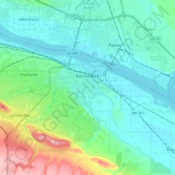
Nombre: Mapa topográfico Kennewick, altitud, relieve.
Lugar: Kennewick, Benton County, Washington, United States (46.15440 -119.26685 46.24054 -119.08721)
Altitud media: 157 m
Altitud mínima: 100 m
Altitud máxima: 362 m
Haz una donación
Equípate para tu próxima aventura:
Como asociado de Amazon, este sitio gana comisiones por las compras que califican, sin ningún costo adicional para usted.
Otros mapas topográficos
Haga clic en un mapa para ver su topografía, su altitud y su relieve.
Haz una donación
Equípate para tu próxima aventura:
Como asociado de Amazon, este sitio gana comisiones por las compras que califican, sin ningún costo adicional para usted.