
Mapa topográfico Loch Lomond and The Trossachs National Park
Mapa interactivo
Haga clic en el mapa para ver la altitud.
Acerca de este mapa
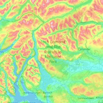
Nombre: Mapa topográfico Loch Lomond and The Trossachs National Park, altitud, relieve.
Altitud media: 291 m
Altitud mínima: -1 m
Altitud máxima: 1.137 m
The park straddles the Highland Boundary Fault, which divides it into two distinct regions - lowland and highland - that differ in underlying geology, soil types and topography. The change in rock type can most clearly be seen at Loch Lomond itself, as the fault runs across the islands of Inchmurrin, Creinch, Torrinch and Inchcailloch and over the ridge of Conic Hill. To the south lie green fields and cultivated land; to the north, mountains.
Otros mapas topográficos
Haga clic en un mapa para ver su topografía, su altitud y su relieve.
Bridge of Allan
United Kingdom > Scotland > Stirling
Bridge of Allan, Stirling, Scotland, FK9 4HW, United Kingdom
Altitud media: 80 m
Gartmore
United Kingdom > Scotland > Stirling
Gartmore, Stirling, Scotland, FK8 3RW, United Kingdom
Altitud media: 55 m
Doon Hill
United Kingdom > Scotland > Stirling > Aberfoyle
Doon Hill, Aberfoyle, Stirling, Scotland, FK8 3UX, United Kingdom
Altitud media: 60 m