
Mapa topográfico Bridge of Allan
Mapa interactivo
Haga clic en el mapa para ver la altitud.
Acerca de este mapa
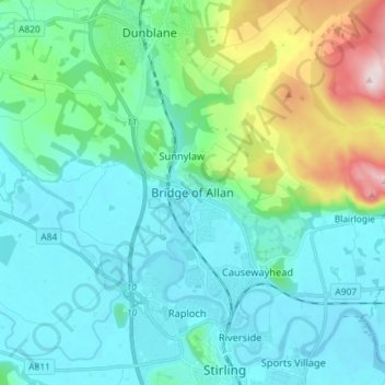
Nombre: Mapa topográfico Bridge of Allan, altitud, relieve.
Lugar: Bridge of Allan, Stirling, Scotland, FK9 4HW, United Kingdom (56.11504 -3.98807 56.19504 -3.90807)
Altitud media: 80 m
Altitud mínima: -1 m
Altitud máxima: 416 m
Otros mapas topográficos
Haga clic en un mapa para ver su topografía, su altitud y su relieve.
Loch Lomond and The Trossachs National Park
United Kingdom > Scotland > Stirling
Loch Lomond and The Trossachs National Park, Stirling, Scotland, United Kingdom
Altitud media: 291 m
Gartmore
United Kingdom > Scotland > Stirling
Gartmore, Stirling, Scotland, FK8 3RW, United Kingdom
Altitud media: 55 m
Doon Hill
United Kingdom > Scotland > Stirling > Aberfoyle
Doon Hill, Aberfoyle, Stirling, Scotland, FK8 3UX, United Kingdom
Altitud media: 60 m