
Mapa topográfico Sandridge
Haga clic en el mapa para ver la altitud.
Acerca de este mapa
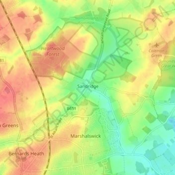
Nombre: Mapa topográfico Sandridge, altitud, relieve.
Lugar: Sandridge, St Albans, Hertfordshire, England, United Kingdom (51.75716 -0.33751 51.80346 -0.26699)
Altitud media: 105 m
Altitud mínima: 73 m
Altitud máxima: 134 m
Otros mapas topográficos
Haga clic en un mapa para ver su topografía, su altitud y su relieve.
St Albans
United Kingdom > England > Hertfordshire > St Albans
St Albans was an ancient borough created following the dissolution of the monastery in 1539. It consisted of the ancient parish of St Albans (also known as the Abbey parish) and parts of St Michael and St Peter. The municipal corporation was reformed by the Municipal Corporations Act 1835 and the boundary was…
Altitud media: 100 m
Highfield Park
United Kingdom > England > Hertfordshire > St Albans > Colney Heath
Altitud media: 87 m
Blackmore End
United Kingdom > England > Hertfordshire > St Albans > Wheathampstead
Altitud media: 114 m
Lower Gustard Wood
United Kingdom > England > Hertfordshire > St Albans > Wheathampstead
Altitud media: 112 m
Napsbury Park
United Kingdom > England > Hertfordshire > St Albans > London Colney
Altitud media: 78 m