
Haz una donación
Equípate para tu próxima aventura:
Como asociado de Amazon, este sitio gana comisiones por las compras que califican, sin ningún costo adicional para usted.
Mapa topográfico Mount Hillers
Haga clic en el mapa para ver la altitud.
Haz una donación
Equípate para tu próxima aventura:
Como asociado de Amazon, este sitio gana comisiones por las compras que califican, sin ningún costo adicional para usted.
Acerca de este mapa
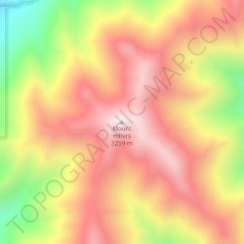
Nombre: Mapa topográfico Mount Hillers, altitud, relieve.
Lugar: Mount Hillers, Garfield County, Utah, United States (37.88730 -110.69698 37.88740 -110.69688)
Altitud media: 2.934 m
Altitud mínima: 2.442 m
Altitud máxima: 3.267 m
Haz una donación
Equípate para tu próxima aventura:
Como asociado de Amazon, este sitio gana comisiones por las compras que califican, sin ningún costo adicional para usted.
Otros mapas topográficos
Haga clic en un mapa para ver su topografía, su altitud y su relieve.
Haz una donación
Equípate para tu próxima aventura:
Como asociado de Amazon, este sitio gana comisiones por las compras que califican, sin ningún costo adicional para usted.
Bryce Canyon National Park
United States > Utah > Garfield County
Bryce Canyon National Park (/braɪs/) is an American national park located in southwestern Utah. The major feature of the park is Bryce Canyon, which despite its name, is not a canyon, but a collection of giant natural amphitheaters along the eastern side of the Paunsaugunt Plateau. Bryce is distinctive due to…
Altitud media: 2.259 m
Escalante Petrified Forest State Park
United States > Utah > Garfield County > Escalante
Altitud media: 1.832 m
Haz una donación
Equípate para tu próxima aventura:
Como asociado de Amazon, este sitio gana comisiones por las compras que califican, sin ningún costo adicional para usted.
Bryce Canyon National Park
United States > Utah > Garfield County
Bryce Canyon National Park (/braɪs/) is an American national park located in southwestern Utah. The major feature of the park is Bryce Canyon, which despite its name, is not a canyon, but a collection of giant natural amphitheaters along the eastern side of the Paunsaugunt Plateau. Bryce is distinctive due to…
Altitud media: 2.259 m
Haz una donación
Equípate para tu próxima aventura:
Como asociado de Amazon, este sitio gana comisiones por las compras que califican, sin ningún costo adicional para usted.
Panguitch
United States > Utah > Garfield County
Panguitch has a cool semi-arid climate (Köppen BSk) with summers featuring hot afternoons and cold mornings, and cold, dry winters. The high altitude and relatively high latitude means that mornings are cold throughout the year and freezing for most of it: between 1971 and 2000 an average of 227.7 mornings…
Altitud media: 2.043 m
Haz una donación
Equípate para tu próxima aventura:
Como asociado de Amazon, este sitio gana comisiones por las compras que califican, sin ningún costo adicional para usted.
Haz una donación
Equípate para tu próxima aventura:
Como asociado de Amazon, este sitio gana comisiones por las compras que califican, sin ningún costo adicional para usted.
Panguitch
United States > Utah > Garfield County
Panguitch has a cool semi-arid climate (Köppen BSk) with summers featuring hot afternoons and cold mornings, and cold, dry winters. The high altitude and relatively high latitude means that mornings are cold throughout the year and freezing for most of it: between 1971 and 2000 an average of 227.7 mornings…
Altitud media: 2.043 m
Haz una donación
Equípate para tu próxima aventura:
Como asociado de Amazon, este sitio gana comisiones por las compras que califican, sin ningún costo adicional para usted.